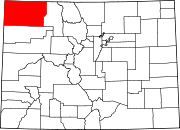
Unincorporated community in Colorado, United States
| Hamilton, Colorado | |
|---|---|
| Unincorporated community | |
  | |
| Coordinates: 40°22′02″N 107°36′47″W / 40.36722°N 107.61306°W / 40.36722; -107.61306 | |
| Country | |
| State | |
| Counties | Moffat |
| Elevation | 6,244 ft (1,903 m) |
| Time zone | UTC-7 (MST) |
| • Summer (DST) | UTC-6 (MDT) |
| ZIP code | 81638 |
| Area code | 970 |
| GNIS feature ID | 171491 |
Hamilton is an unincorporated community with a U.S. Post Office in Moffat County, Colorado, United States. The Hamilton Post Office has the ZIP Code 81638.
Climate
Craig 4SW is a weather station near Hamilton. Craig 4SW has a humid continental climate (Köppen Dfb).
| Climate data for Craig 4SW, Colorado, 1991–2020 normals, 1977-2020 records: 6496ft (1980m) | |||||||||||||
|---|---|---|---|---|---|---|---|---|---|---|---|---|---|
| Month | Jan | Feb | Mar | Apr | May | Jun | Jul | Aug | Sep | Oct | Nov | Dec | Year |
| Record high °F (°C) | 57 (14) |
63 (17) |
76 (24) |
80 (27) |
88 (31) |
98 (37) |
99 (37) |
96 (36) |
97 (36) |
85 (29) |
73 (23) |
60 (16) |
99 (37) |
| Mean maximum °F (°C) | 44.7 (7.1) |
50.2 (10.1) |
64.7 (18.2) |
73.2 (22.9) |
80.8 (27.1) |
89.2 (31.8) |
93.4 (34.1) |
91.5 (33.1) |
86.6 (30.3) |
77.4 (25.2) |
63.8 (17.7) |
49.3 (9.6) |
94.1 (34.5) |
| Mean daily maximum °F (°C) | 30.3 (−0.9) |
35.3 (1.8) |
46.9 (8.3) |
56.0 (13.3) |
65.7 (18.7) |
77.8 (25.4) |
85.2 (29.6) |
83.2 (28.4) |
74.6 (23.7) |
60.6 (15.9) |
44.8 (7.1) |
31.9 (−0.1) |
57.7 (14.3) |
| Daily mean °F (°C) | 18.6 (−7.4) |
23.0 (−5.0) |
33.4 (0.8) |
41.5 (5.3) |
50.6 (10.3) |
60.3 (15.7) |
67.4 (19.7) |
65.7 (18.7) |
57.0 (13.9) |
44.4 (6.9) |
31.6 (−0.2) |
20.3 (−6.5) |
42.8 (6.0) |
| Mean daily minimum °F (°C) | 7.0 (−13.9) |
10.8 (−11.8) |
19.9 (−6.7) |
27.0 (−2.8) |
35.5 (1.9) |
42.8 (6.0) |
49.6 (9.8) |
48.2 (9.0) |
39.3 (4.1) |
28.3 (−2.1) |
18.4 (−7.6) |
8.8 (−12.9) |
28.0 (−2.3) |
| Mean minimum °F (°C) | −12.0 (−24.4) |
−7.1 (−21.7) |
5.0 (−15.0) |
16.0 (−8.9) |
25.6 (−3.6) |
34.5 (1.4) |
42.9 (6.1) |
41.3 (5.2) |
28.8 (−1.8) |
14.0 (−10.0) |
0.2 (−17.7) |
−10.4 (−23.6) |
−17.0 (−27.2) |
| Record low °F (°C) | −36 (−38) |
−41 (−41) |
−13 (−25) |
−1 (−18) |
18 (−8) |
23 (−5) |
34 (1) |
31 (−1) |
16 (−9) |
−10 (−23) |
−16 (−27) |
−31 (−35) |
−41 (−41) |
| Average precipitation inches (mm) | 1.20 (30) |
1.10 (28) |
1.28 (33) |
1.85 (47) |
1.88 (48) |
1.08 (27) |
1.19 (30) |
1.28 (33) |
1.79 (45) |
1.83 (46) |
1.42 (36) |
1.45 (37) |
17.35 (440) |
| Average snowfall inches (cm) | 14.5 (37) |
11.0 (28) |
8.7 (22) |
5.1 (13) |
1.2 (3.0) |
trace | 0.0 (0.0) |
0.0 (0.0) |
trace | 3.2 (8.1) |
9.0 (23) |
14.9 (38) |
67.6 (172.1) |
| Average extreme snow depth inches (cm) | 11.2 (28) |
9.8 (25) |
6.6 (17) |
3.1 (7.9) |
1.1 (2.8) |
0.0 (0.0) |
0.0 (0.0) |
0.0 (0.0) |
0.4 (1.0) |
2.7 (6.9) |
5.0 (13) |
9.3 (24) |
14.0 (36) |
| Average precipitation days (≥ 0.01 in) | 7 | 6 | 6 | 7 | 7 | 5 | 5 | 6 | 6 | 6 | 6 | 6 | 73 |
| Average snowy days (≥ 0.1 in) | 8 | 6 | 5 | 3 | 1 | 0 | 0 | 0 | 0 | 1 | 4 | 6 | 34 |
| Source 1: NOAA | |||||||||||||
| Source 2: XMACIS2 (records, monthly max/mins, snow & precip/snow days) | |||||||||||||
References
- ^ U.S. Geological Survey Geographic Names Information System: Hamilton, Colorado
- ^ "ZIP Code Lookup". United States Postal Service. December 15, 2006. Archived from the original (JavaScript/HTML) on September 3, 2007. Retrieved December 15, 2006.
- "Data of Meteorological Station Craig 4Sw, Colorado". geographic.org. Retrieved January 7, 2024.
- "Craig 4SW, Colorado 1991-2020 Monthly Normals". Retrieved January 7, 2024.
- "xmACIS". National Oceanic and Atmospheric Administration. Retrieved January 7, 2024.
| Municipalities and communities of Moffat County, Colorado, United States | ||
|---|---|---|
| County seat: Craig | ||
| City |  | |
| Town | ||
| CDP | ||
| Unincorporated communities | ||
| Ghost towns | ||