| This article needs additional citations for verification. Please help improve this article by adding citations to reliable sources. Unsourced material may be challenged and removed. Find sources: "Gonjo County" – news · newspapers · books · scholar · JSTOR (August 2023) (Learn how and when to remove this message) |
| Gonjo County 贡觉县 • གོ་འཇོ་རྫོང་། | |
|---|---|
| County | |
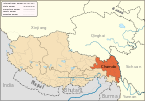
 Location of Gonjo County within Tibet Autonomous Region Location of Gonjo County within Tibet Autonomous Region | |
  | |
| Coordinates: 30°51′37″N 98°16′21″E / 30.86028°N 98.27250°E / 30.86028; 98.27250 | |
| Country | China |
| Autonomous region | Tibet |
| Prefecture-level city | Chamdo |
| County seat | Bolo |
| Area | |
| • Total | 6,322.55 km (2,441.15 sq mi) |
| Population | |
| • Total | 40,009 |
| • Density | 6.3/km (16/sq mi) |
| Time zone | UTC+8 (China Standard) |
| Website | gongjue |
| Gonjo County | |||||||
|---|---|---|---|---|---|---|---|
| Chinese name | |||||||
| Simplified Chinese | 贡觉县 | ||||||
| Traditional Chinese | 貢覺縣 | ||||||
| |||||||
| Tibetan name | |||||||
| Tibetan | གོ་འཇོ་རྫོང་། | ||||||
| |||||||
Gonjo County (Tibetan: གོ་འཇོ་རྫོང་; Chinese: 贡觉县) is a county of the Chamdo Prefecture in the east of the Tibet Autonomous Region, China, bordering Sichuan province to the east.
Administrative divisions
Gonjo County is divided in 1 town and 11 townships.

| Name | Chinese | Hanyu Pinyin | Tibetan | Wylie | ||
|---|---|---|---|---|---|---|
| Town | ||||||
| Bolo Town | 莫洛镇 | Mòluò zhèn | འབོ་ལོ་གྲོང་རྡལ། | 'bo lo grong rdal | ||
| Townships | ||||||
| Gyanbê Township | 相皮乡 | Xiàngpí xiāng | སྐྱ་འབེལ་ཤང་། | skya 'bel shang | ||
| Lha'gyai Township | 哈加乡 | Hājiā xiāng | ལྷ་རྒྱལ་ཤང་། | lha rgyal shang | ||
| Qangsum Township | 雄松乡 | Xióngsōng xiāng | བྱང་གསུམ་ཤང་། | byang gsum shang | ||
| Lhato Township | 拉妥乡 | Lātuǒ xiāng | ལྷ་ཐོ་ཤང་། | lha tho shang | ||
| Awang Township | 阿旺乡 | Āwàng xiāng | ཨ་དབང་ཤང་། | a dbang shang | ||
| Bumgyê Township | 木协乡 | Mùxié xiāng | འབུམ་སྐྱེས་ཤང་། | 'bum skyes shang | ||
| Langmai Township | 罗麦乡 | Luómài xiāng | གླང་སྨད་ཤང་། | glang smad shang | ||
| Sêrdong Township | 沙东乡 | Shādōng xiāng | གསེར་གདོང་ཤང་། | gser gdong shang | ||
| Kêrri Township | 克日乡 | Kèrì xiāng | ཁེར་རི་ཤང་། | kher ri shang | ||
| Zêba Township | 则巴乡 | Zébā xiāng | རྩེ་བ་ཤང་། | rtse ba shang | ||
| Mindo Township | 敏都乡 | Mǐndū xiāng | མིག་མདོ་ཤང་། | mig mdo shang | ||
References
- "昌都市第七次全国人口普查主要数据公报" (in Chinese). Government of Chamdo. 2021-06-22.
| County-level divisions of Tibet Autonomous Region | |||||||||||||
|---|---|---|---|---|---|---|---|---|---|---|---|---|---|
| Lhasa (capital) | |||||||||||||
| Prefecture-level cities |
| ||||||||||||
| Prefecture |
| ||||||||||||
| ** Southern portions of these counties are claimed by the People's Republic of China as part of the South Tibet area, but are administered by India. | |||||||||||||
| Chamdo | ||||||
|---|---|---|---|---|---|---|
| County-level divisions |
|  | ||||
| Settlements | ||||||
| Sciences | ||||||
| Cultures | ||||||
This Chamdo, Tibet location article is a stub. You can help Misplaced Pages by expanding it. |