| This article needs additional citations for verification. Please help improve this article by adding citations to reliable sources. Unsourced material may be challenged and removed. Find sources: "Glenloch Interchange" – news · newspapers · books · scholar · JSTOR (October 2021) (Learn how and when to remove this message) |
| Glenloch Interchange Australian Capital Territory | |
|---|---|
 | |
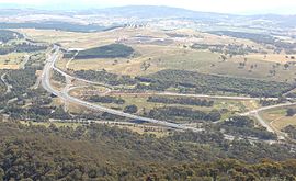
| View from nearby Black Mountain Tower, November 2012. | |
 | |
| Coordinates | |
| General information | |
| Type | Road junction |
| Junction type | Modified partial three-level turbine interchange |
| Location | Molonglo Valley, Canberra |
| Spans | 6 |
| Maintained by | Territory and Municipal Services |
| Roads at junction |
|
The Glenloch Interchange is major road interchange in Canberra, Australia. It one of the busiest road interchanges in the Australian Capital Territory, connecting the Tuggeranong Parkway with Parkes Way, William Hovell Drive and Caswell Drive (Gungahlin Drive Extension).
History
The interchange was originally built in the 1970s.
A major reconstruction lasting from 2007 to mid-2008 removed traffic lights from the interchange. The new alignment resulted in retention of a bridge over both Caswell Drive and William Hovell Drive that was disconnected as a result of the works. This was finally removed in late 2010 during roadworks to upgrade the new interchange to dual carriageway standards.
In 2021, the ACT Government identified the Glenloch Interchange as a focal point when planning for major upgrades of the transport corridors connecting the city with districts in the south and west.
 View of Glenloch Interchange, approaching via Caswell Drive (Gungahlin Drive Extension).
See also
References
- "Glenloch Interchange, Canberra, Australia Photos". www.touristlink.com. Retrieved 2 October 2021.
- "Glenloch Interchange photos". Tourist link. Retrieved 2 October 2021.
- "#20777 - View from Black Mountain". Canberra and District Historical Society. Retrieved 5 June 2024.
- Ian Bushnell (18 May 2021). "Government bracing for traffic surge on Parkes Way, Tuggeranong Parkway". RiotACT. Retrieved 5 June 2024.
| Locations near Lake Burley Griffin, Canberra | |||||||
|---|---|---|---|---|---|---|---|
| Yarramundi Reach Tarcoola Reach West Lake |
| ||||||
| West Basin |
| ||||||
| Central Basin |
| ||||||
| East Basin | |||||||
| Controlled-access roads: | ||
|---|---|---|
| Limited-access roads: |
| |
| Bridges: | ||
| Major interchanges: | ||
| Related articles: | ||
|
Partially limited-access Partially controlled-access roadway under construction | ||
This article on the geography of the Australian Capital Territory is a stub. You can help Misplaced Pages by expanding it. |
This Australian road or road transport-related article is a stub. You can help Misplaced Pages by expanding it. |