Human settlement in England
| Ermine | |
|---|---|
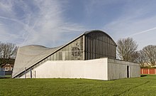
 Ermine Estate, Lincoln Ermine Estate, Lincoln | |
 | |
| Population | (2021) |
| District | |
| Shire county | |
| Region | |
| Country | England |
| Sovereign state | United Kingdom |
| Post town | LINCOLN |
| Postcode district | LN1 |
| Dialling code | 01522 |
| Police | Lincolnshire |
| Fire | Lincolnshire |
| Ambulance | East Midlands |
| UK Parliament | |
| |

Ermine is an inner-city suburb and housing estate of Lincoln in Lincolnshire, England. Located to the north of the city, it is named after Ermine Street. The area is one of the city's largest suburbs and was at one point the roughest area of Lincoln. It also includes the neighborhoods of Ermine East and Ermine West.
References
- Walker, Andrew (2009). Uphill Lincoln: Burton Road, Newport, and the Ermine Estate. I. Survey of Lincoln Project. ISBN 978-0-9538650-4-8. Retrieved 13 June 2024.
- "Lincoln council flat tenants speak out against 'run down' conditions". The Lincolnite. 30 November 2023. Retrieved 13 June 2024.
- "The Survey of Lincoln - Uphill Lincoln I: Burton Road, Newport & the Ermine Estate". www.thesurveyoflincoln.co.uk. Retrieved 13 June 2024.
- "Living the dream: The truth about 'Lincoln's roughest neighbourhood'". The Lincolnite. 15 July 2022. Retrieved 13 June 2024.
- Dreams, Municipal (23 June 2015). "The Ermine Estate, Lincoln: 'Social Democracy in Action'". Municipal Dreams. Retrieved 13 June 2024.