| This article relies largely or entirely on a single source. Relevant discussion may be found on the talk page. Please help improve this article by introducing citations to additional sources. Find sources: "Ehrichspitze" – news · newspapers · books · scholar · JSTOR (November 2024) |
| Ehrichspitze | |
|---|---|
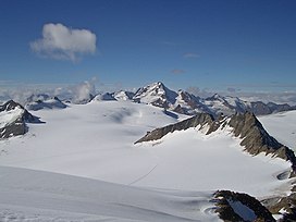
 View from the Fluchtkogel to the southwest over the Kesselwandferner (foreground) and the massive Gepatschferner (background and right). The Brandenburger Haus is in the middle of the picture, at the foot of the double peaks Dahmannspitze and Ehrichspitze (right) that are embedded in the glaciers. In the background are the Hintereisspitzen (left) and Weißkugel (3736 m). View from the Fluchtkogel to the southwest over the Kesselwandferner (foreground) and the massive Gepatschferner (background and right). The Brandenburger Haus is in the middle of the picture, at the foot of the double peaks Dahmannspitze and Ehrichspitze (right) that are embedded in the glaciers. In the background are the Hintereisspitzen (left) and Weißkugel (3736 m). | |
| Highest point | |
| Elevation | 3,420 m (11,220 ft) |
| Prominence | 115 m (377 ft) |
| Parent peak | Fluchtkogel |
| Coordinates | 46°50′57″N 10°46′34″E / 46.84917°N 10.77611°E / 46.84917; 10.77611 |
| Geography | |
 | |
| Location | Tyrol, Austria |
| Parent range | Ötztal Alps |
| Climbing | |
| Easiest route | East face (UIAA-II) |
The Ehrichspitze is a mountain in the Weisskamm group of the Ötztal Alps.
References
- Klier, Walter (2006). Ötztaler Alpen. Bergverlag Rother. ISBN 978-3-7633-1123-1.
This Tyrol location article is a stub. You can help Misplaced Pages by expanding it. |