| Ecuador–Peru border | |
|---|---|
 | |
| Characteristics | |
| Entities | |
| Length | 1,529 kilometres (950 mi) |
| History | |
| Established | c. 1830 Dissolution of Gran Colombia |
| Current shape | 1998 Brasilia Presidential Act |
| Treaties | See relevant page |
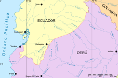
The Ecuador–Peru border is an international border separating Ecuador from Peru. It extends from the Pacific Ocean to the Putumayo River within the Amazon rainforest, first following the Zarumilla and Chira rivers and crossing into the Cordillera del Cóndor.
The history of the border was marked by a territorial dispute up until 1998, when the Brasilia Presidential Act was signed between then presidents Jamil Mahuad and Alberto Fujimori.
The border was closed from 2020 to early 2022 due to the COVID-19 pandemic.
See also
References
- "Acta Presidencial de Brasilia". Congress of Peru. Archived from the original on 2022-10-20. Retrieved 2023-03-06.
- "Ecuador reabre su frontera terrestre con Perú, cerrada desde inicios del 2020". Gestión. 2022-02-18.