Township in Ontario, Canada
| Machin | |
|---|---|
| Township (single-tier) | |
| Township of Machin | |
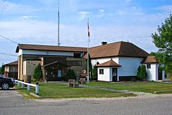
 Township office in Vermilion Bay Township office in Vermilion Bay | |
 | |
| Coordinates: 49°47′N 93°10′W / 49.783°N 93.167°W / 49.783; -93.167 | |
| Country | Canada |
| Province | Ontario |
| District | Kenora |
| Incorporated | 1909 |
| Government | |
| • Mayor | Gordon Griffiths |
| • Federal riding | Kenora |
| • Prov. riding | Kenora—Rainy River |
| Area | |
| • Land | 290.14 km (112.02 sq mi) |
| Population | |
| • Total | 1,012 |
| • Density | 3.5/km (9/sq mi) |
| Time zone | UTC-6 (CST) |
| • Summer (DST) | UTC-5 (CDT) |
| Postal Code FSA | P0V |
| Area code | 807 |
| Website | www |
Machin is a township in the Canadian province of Ontario, located in the Kenora District west of Dryden.
The township, named after Harold A.C. Machin, consists of 2 non-contiguous areas on the north shore of Eagle Lake. The junction of Highway 17 and Highway 105 is located in Machin, just east of Vermilion Bay.
Communities

The main communities in Machin township are Eagle River (49°47′31″N 93°11′41″W / 49.79194°N 93.19472°W / 49.79194; -93.19472), Minnitaki (49°48′46″N 93°5′41″W / 49.81278°N 93.09472°W / 49.81278; -93.09472), and Vermilion Bay (49°51′23″N 93°22′55″W / 49.85639°N 93.38194°W / 49.85639; -93.38194).
Eagle River
The community of Eagle River has its origin as a Hudson's Bay Company fur-trading post on Eagle Lake, founded in 1869. It operated seasonally in the winter until 1882, when the post was moved to Wabigoon Lake. By that time, the Canadian Pacific Railway was built through the area and the settlement grew where the railroad crosses the namesake Eagle River. In the 1890s, Eagle River was an important coal and water supply station for the railroad, while shipping out wood and fur.
Trade at Eagle River ceased in 1903. In 1928, a hydro-electric power station was built on the river (and another one in 1937). Around 1935/1936, the first fishing and hunting lodge was built on Eagle Lake. The community lost later its importance as a railroad hub, and in 1968 and 1969, railway docks were removed and its train station was demolished in 1973.
Minnitaki

Minnitaki started as a railway point along the Canadian Pacific Railway, which was built in the early 1880s. Its indigenous name means "muddy waters" or "shaded waters", either referring to the murky waters of Beaver Creek that flows through the place or to the shadow cast on water by passing clouds.
In 1896, the geographic townships of Eton, Sanford, and Aubrey were surveyed, after which the first homesteaders founded the settlement.
Demographics
In the 2021 Census of Population conducted by Statistics Canada, Machin had a population of 1,012 living in 457 of its 632 total private dwellings, a change of 4.2% from its 2016 population of 971. With a land area of 290.14 km (112.02 sq mi), it had a population density of 3.5/km (9.0/sq mi) in 2021.
Canada census – Machin community profile| 2021 | 2016 | 2011 | |
|---|---|---|---|
| Population | 1,012 (+4.2% from 2016) | 971 (+3.9% from 2011) | 935 (-4.4% from 2006) |
| Land area | 290.14 km (112.02 sq mi) | 291.81 km (112.67 sq mi) | 289.84 km (111.91 sq mi) |
| Population density | 3.5/km (9.1/sq mi) | 3.3/km (8.5/sq mi) | 3.2/km (8.3/sq mi) |
| Median age | 53.6 (M: 53.6, F: 52.8) | 50.6 (M: 50.1, F: 50.9) | 47.0 (M: 48.5, F: 46.0) |
| Private dwellings | 632 (total) 457 (occupied) | 597 (total) | 560 (total) |
| Median household income | $77,500 | $70,464 |
|
|
| |||||||||||||||||||||||||||||||||||||||||||||||||||||||||||||||
| Population counts are not adjusted for boundary changes. Source: Statistics Canada | |||||||||||||||||||||||||||||||||||||||||||||||||||||||||||||||||
See also
References
- ^ "Machin, Ontario (Code 3560021) Census Profile". 2021 census. Government of Canada - Statistics Canada. Retrieved 2025-01-02.
- ^ "The History of the Municipality of Machin". www.visitmachin.com. Municipality of Machin. Retrieved 2 January 2025.
- "Eagle River". Geographical Names Data Base. Natural Resources Canada. Retrieved 2 January 2025.
- "Minnitaki". Geographical Names Data Base. Natural Resources Canada. Retrieved 2 January 2025.
- "Vermilion Bay". Geographical Names Data Base. Natural Resources Canada. Retrieved 2 January 2025.
- "2021 Community Profiles". 2021 Canadian census. Statistics Canada. February 4, 2022. Retrieved 2023-10-19.
- "2016 Community Profiles". 2016 Canadian census. Statistics Canada. August 12, 2021. Retrieved 2019-06-06.
- "2011 Community Profiles". 2011 Canadian census. Statistics Canada. March 21, 2019. Retrieved 2012-04-03.
- "Machin, Ontario (Code 3560021) Census Profile". 2011 census. Government of Canada - Statistics Canada. 2012.
- "1971 Census of Canada - Population Census Subdivisions (Historical)". Catalogue 92-702 Vol I, part 1 (Bulletin 1.1-2). Statistics Canada: 76, 139. July 1973.
External links
| Places adjacent to Machin, Ontario | ||||||||||||||||
|---|---|---|---|---|---|---|---|---|---|---|---|---|---|---|---|---|
| ||||||||||||||||
