| Duncan Town Airport | |||||||||||
|---|---|---|---|---|---|---|---|---|---|---|---|
| Summary | |||||||||||
| Airport type | Public | ||||||||||
| Serves | Ragged Island, Bahamas | ||||||||||
| Location | Duncan Town | ||||||||||
| Elevation AMSL | 6 ft / 2 m | ||||||||||
| Coordinates | 22°10′54″N 075°43′46″W / 22.18167°N 75.72944°W / 22.18167; -75.72944 | ||||||||||
| Map | |||||||||||
 | |||||||||||
| Runways | |||||||||||
| |||||||||||
| Source: DAFIF | |||||||||||
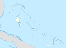
Duncan Town Airport (IATA: DCT, ICAO: MYRD) is an airport located near Duncan Town, on Ragged Island in The Bahamas.
Facilities
The airport resides at an elevation of 6 ft (1.8 m) above mean sea level. It has one runway designated 13/31 with an asphalt surface measuring 1,158 m × 23 m (3,799 ft × 75 ft).
References
- ^ "Airport information for MYRD". World Aero Data. Archived from the original on 2019-03-05. Data current as of October 2006. Source: DAFIF.
- Airport information for DCT at Great Circle Mapper. Source: DAFIF (effective October 2006).
External links
This article about a Caribbean airport is a stub. You can help Misplaced Pages by expanding it. |
This article about a Bahamian building or structure related topic is a stub. You can help Misplaced Pages by expanding it. |