| Donji Kraljevec | |
|---|---|
| Municipality | |
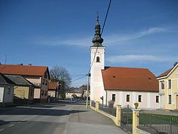
 Village centre Village centre | |
 | |
| Coordinates: 46°22′N 16°39′E / 46.367°N 16.650°E / 46.367; 16.650 | |
| Country | |
| County | Međimurje |
| Seat | Donji Kraljevec |
| Settlements |
List
|
| Government | |
| • Municipal mayor | Miljenko Horvat |
| Area | |
| • Municipality | 36.3 km (14.0 sq mi) |
| • Urban | 11.5 km (4.4 sq mi) |
| Population | |
| • Municipality | 4,043 |
| • Density | 110/km (290/sq mi) |
| • Urban | 1,407 |
| • Urban density | 120/km (320/sq mi) |
| Time zone | UTC+1 (CET) |
| • Summer (DST) | UTC+2 (CEST) |
| Postal code | 40320 Donji Kraljevec |
| Website | donjikraljevec |
Donji Kraljevec (Hungarian: Murakirály) is a village and municipality in Međimurje County, Croatia.
Geography and demographics

In the 2011 census, the municipality had a population of 4,659. Of the entire population, a total of 4,578 people (98.3%) identified themselves as Croats.
The village of Donji Kraljevec is located around 20 kilometres south-east of Čakovec, the county seat and largest city of Međimurje County, and just over 4 kilometres north-east of Prelog, the second largest city of the county. In the 2001 census, the village had a population of 1,694 and was also the largest village in the municipality.
In addition to Donji Kraljevec (population 1560), there were five other villages belonging to the municipality during the 2011 census:
- Donji Hrašćan – 547 people
- Donji Pustakovec – 286 people
- Hodošan – 1,254 people
- Palinovec – 712 people
- Sveti Juraj u Trnju – 300 people
Sport
The nearby Stadium Milenium is a speedway stadium and hosts the Speedway Grand Prix of Croatia.
Notable people
- Rudolf Steiner - philosopher
References
- Register of spatial units of the State Geodetic Administration of the Republic of Croatia. Wikidata Q119585703.
- "Population by Age and Sex, by Settlements" (xlsx). Census of Population, Households and Dwellings in 2021. Zagreb: Croatian Bureau of Statistics. 2022.
- Donji Kraljevec, Hrvatska enciklopedija, mrežno izdanje. Leksikografski zavod Miroslav Krleža, 2021. Pristupljeno 9. 11. 2021.
- "Population by Ethnicity, by Towns/Municipalities, 2011 Census: County of Međimurje". Census of Population, Households and Dwellings 2011. Zagreb: Croatian Bureau of Statistics. December 2012.
- "Population by Age and Sex, by Settlements, 2011 Census: Donji Kraljevec". Census of Population, Households and Dwellings 2011. Zagreb: Croatian Bureau of Statistics. December 2012.
- "DONJI KRALJEVEC CROATIA". FIM. Archived from the original on 23 January 2023. Retrieved 23 January 2023.
External links
| Subdivisions of Međimurje County | ||
|---|---|---|
| Towns |
|  |
| Municipalities | ||
46°22′12″N 16°39′0″E / 46.37000°N 16.65000°E / 46.37000; 16.65000
This Međimurje County geography article is a stub. You can help Misplaced Pages by expanding it. |