| This article does not cite any sources. Please help improve this article by adding citations to reliable sources. Unsourced material may be challenged and removed. Find sources: "Digital Cadastral DataBase" – news · newspapers · books · scholar · JSTOR (May 2019) (Learn how and when to remove this message) |

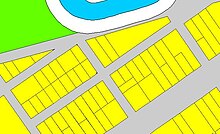
Digital Cadastral DataBase (DCDB) is a computerised map or 'spatial' location showing property boundaries normally in relation to adjoining and other close properties or parcels of land. Commonly used as a basic layer of data used in map based computer programs that gives an outline of the legal boundaries of a property. By using lines to represent an area, features such as rivers and roads can be shown in relation to the property location.