| Dhupguri subdivision | |
|---|---|
| Subdivision | |
 | |
| Coordinates: 26°35′N 89°01′E / 26.59°N 89.01°E / 26.59; 89.01 | |
| Country | India |
| State | West Bengal |
| District | Jalpaiguri |
| Formation | 19 January 2024 (2024-01-19) |
| Headquarters | Dhupguri |
| Languages | |
| • Official | Bengali, English |
| Time zone | UTC+5:30 (IST) |
| ISO 3166 code | ISO 3166-2:IN |
| Vehicle registration | WB-71/WB-72 |
| Website | jalpaiguri |
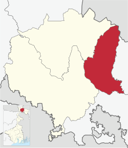
Dhupguri subdivision is an administrative division of Jalpaiguri district in the state of West Bengal, India.
History
The subdivision was previously part of the Jalpaiguri Sadar subdivision. Following the death of Bishnu Pada Roy, a local Bharatiya Janata Party MLA from Dhupguri, a by-election was held in 2023. The ruling Trinamool Congress (TMC) government promised that if they won the seat, they would establish a separate subdivision within three months. After TMC won the seat, the state assembly passed the motion to form the subdivision on 12 October 2023. The subdivision was officially established on 20 January 2024.
Administrative units
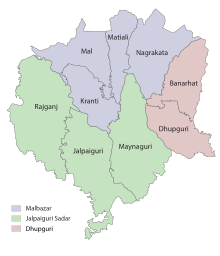
The subdivision will be carved out of Dhupguri town, Banarhat block, and parts of Malbazar. As a result, Jalpaiguri district will have three subdivisions, the others being Jalpaiguri Sadar and Malbazar subdivisions.

Police stations
Dhupguri and Banarhat have their own police stations that falls under the Jalpaiguri Police district of West Bengal Police.
Gram Panchayats
The subdivision contains 16 gram panchayats under 2 community development blocks:
- Dhupguri (community development block) consists of nine gram panchayats, viz. Barogharia, Gadhearkuthi, Godong I, Godong II, Jharaltagram I, Magurmari I, Magurmari II, Sakoajhora II, and Salbari II.
- Banarhat (community development block) consists of seven gram panchayats, viz. Sakoajhora-I, Salbari-I, Salbari-II, Banarhat-I, Banarhat-II, Chamurchi and Binnaguri Gram Panchayats.
Population
As of the 2011 Census, total population is 4,14,854.
| Population | Rural | Urban | Total |
|---|---|---|---|
| Male | 1,93,071 | 17,500 | 2,10,571 |
| Female | 1,87,019 | 17,264 | 2,04,283 |
| Density | 813 / km² | 1,272 / km² | 838 / km² |
References
- "Dhupguri subdivision now official". The Times of India. 2024-01-19. ISSN 0971-8257. Retrieved 2025-01-04.
- "Dhupguri bypoll: TMC continues comeback march in north Bengal; subdivision promise, tea garden votes the key". The Indian Express. 2023-09-08. Retrieved 2025-01-04.
- Sinha, Avijit. "Jalpaiguri: Dhupguri now subdivision, chief minister 'delighted'". Telegraph India. Archived from the original on 2024-09-16. Retrieved 2025-01-04.
- PTI (2024-01-18). "Legal hassles over, Dhupguri is now a subdivision of Bengal: Mamata". ThePrint. Retrieved 2025-01-05.
- Bharat, E. T. V. (2024-01-20). "'Dhupguri officially attains status of subdivision', announces Mamata Banerjee". ETV Bharat News. Retrieved 2025-01-05.
- "Jalpaiguri". District Profile. District administration. Retrieved 10 January 2025.
- "Villages & Towns in Dhupguri Block of Jalpaiguri, West Bengal". www.census2011.co.in. Retrieved 2025-01-05.