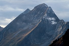
| Dent de Brenleire | |
|---|---|
 Dent de Brenleire and Dent de Folliéran behind Dent de Brenleire and Dent de Folliéran behind | |
| Highest point | |
| Elevation | 2,354 m (7,723 ft) |
| Prominence | 275 m (902 ft) |
| Parent peak | Vanil Noir |
| Coordinates | 46°33′3″N 7°10′29.2″E / 46.55083°N 7.174778°E / 46.55083; 7.174778 |
| Geography | |
 | |
| Location | Fribourg, Switzerland |
| Parent range | Fribourg Alps |
The Dent de Brenleire (French pronunciation: [dɑ̃ d(ə) bʁɑ̃lɛːʁ]; lit. 'Tooth of Branleire') is a mountain of the Fribourg Alps, located south of Charmey in the Swiss canton of Fribourg. It has an elevation of 2,354 metres above sea level and is amongst the highest summits in the canton of Fribourg, after the Vanil Noir, the Vanil de l'Ecri and the Pointe de Paray. It is also the highest mountain entirely within the canton.
The summit of the Dent de Brenleire is accessible by a trail running on the east side of the mountain, from the Gros Mont.
References
- Retrieved from the Swisstopo topographic maps. The key col is located west of Dent de Folliéran at 2,079 m.
External links
This Canton of Fribourg location article is a stub. You can help Misplaced Pages by expanding it. |