| Cromvoirt | |
|---|---|
| Village | |
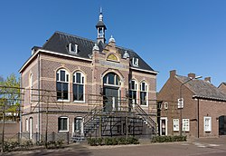
 Former town hall Former town hall | |
 Flag Flag Coat of arms Coat of arms | |
  | |
| Coordinates: 51°40′N 5°14′E / 51.667°N 5.233°E / 51.667; 5.233 | |
| Country | Netherlands |
| Province | North Brabant |
| Municipality | Vught |
| Area | |
| • Total | 6.41 km (2.47 sq mi) |
| Elevation | 6 m (20 ft) |
| Population | |
| • Total | 875 |
| • Density | 140/km (350/sq mi) |
| Time zone | UTC+1 (CET) |
| • Summer (DST) | UTC+2 (CEST) |
| Postal code | 5266 |
| Dialing code | 0411 |
Cromvoirt is a village in the Dutch province of North Brabant. It is located in the municipality of Vught.
History
The village was first mentioned in 1312 as Crumvoert, and means "crooked fordable place".
The Catholic St Lambertus Church was built in 1888. In 1891, the tower was constructed next to the church. The tower was blown up by the Germans in 1944, and only partially restored.
Cromvoirt was home to 393 people in 1840. Cromvoirt was a separate municipality until 1933, when it was merged with Vught. The northern part of the municipality, containing the hamlet Deuteren, became a part of the municipality of 's-Hertogenbosch.
Gallery
References
- ^ "Kerncijfers wijken en buurten 2021". Central Bureau of Statistics. Retrieved 18 April 2022.
- "Postcodetool for 5266AA". Actueel Hoogtebestand Nederland (in Dutch). Het Waterschapshuis. Retrieved 18 April 2022.
- "Cromvoirt - (geografische naam)". Etymologiebank (in Dutch). Retrieved 18 April 2022.
- ^ "Cromvoirt". Plaatsengids (in Dutch). Retrieved 18 April 2022.
- Ad van der Meer and Onno Boonstra, Repertorium van Nederlandse gemeenten, KNAW, 2011.
This North Brabant location article is a stub. You can help Misplaced Pages by expanding it. |


