Misplaced Pages

County of Auburn

Article snapshot taken from Wikipedia with creative commons attribution-sharealike license. Give it a read and then ask your questions in the chat. We can research this topic together.

Cadastral in Queensland, Australia
Auburn
Queensland
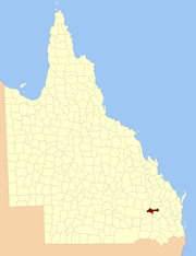
Location within Queensland
Lands administrative divisions around Auburn:
Fortescue Newcastle Newcastle
Bulwer Auburn Boondooma
Bulwer Lytton Lytton
Map all coordinates using OpenStreetMap

Download coordinates as:

County of Auburn map, 2 miles to an inch, 1922

The County of Auburn is a county (a cadastral division) in the Darling Downs region of Queensland, Australia. Much of its area is within the Barakula State Forest. It was named and bounded by the Governor in Council on 7 March 1901 under the Land Act 1897.

Parishes

Auburn is divided into parishes, as listed below:

Parish LGA Coordinates
Athlone Western Downs 26°19′S 150°51′E / 26.317°S 150.850°E / -26.317; 150.850 (Athlone Parish)
Ballon Western Downs 26°25′S 150°51′E / 26.417°S 150.850°E / -26.417; 150.850 (Ballon Parish)
Bartsch Western Downs 26°30′S 150°07′E / 26.500°S 150.117°E / -26.500; 150.117 (Bartsch Parish)
Bembil Western Downs 26°14′S 150°57′E / 26.233°S 150.950°E / -26.233; 150.950 (Bembil Parish)
Binkey Western Downs 26°21′S 150°11′E / 26.350°S 150.183°E / -26.350; 150.183 (Binkey Parish)
Burraburri Western Downs 26°25′S 151°06′E / 26.417°S 151.100°E / -26.417; 151.100 (Burraburri Parish)
Delger Western Downs 26°19′S 151°03′E / 26.317°S 151.050°E / -26.317; 151.050 (Delger Parish)
Hookswood Western Downs 26°29′S 150°21′E / 26.483°S 150.350°E / -26.483; 150.350 (Hookswood Parish)
Macdonald Western Downs 26°21′S 150°40′E / 26.350°S 150.667°E / -26.350; 150.667 (Macdonald Parish)
Malcolm Western Downs 26°20′S 150°29′E / 26.333°S 150.483°E / -26.333; 150.483 (Malcolm Parish)
Pelham Western Downs 26°22′S 150°20′E / 26.367°S 150.333°E / -26.367; 150.333 (Pelham Parish)
Quandong Western Downs 26°14′S 150°18′E / 26.233°S 150.300°E / -26.233; 150.300 (Quandong Parish)
Wongongera Western Downs 26°32′S 150°31′E / 26.533°S 150.517°E / -26.533; 150.517 (Wongongera Parish)

References

  1. "Auburn – county in Western Downs Region (entry 985)". Queensland Place Names. Queensland Government. Retrieved 28 November 2018.
  2. Darling Downs District, County of Auburn Maps – D2 Series at Queensland Archives.

External links

26°25′S 150°37′E / 26.417°S 150.617°E / -26.417; 150.617

Category:
County of Auburn Add topic