| Colanguil | |
|---|---|
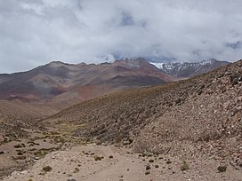
 Colangüil as seen from the northeast Colangüil as seen from the northeast | |
| Highest point | |
| Elevation | 6,122 m (20,085 ft) |
| Prominence | 1,547 metres (5,075 ft) |
| Parent peak | Majadita |
| Coordinates | 29°35′20.75″S 069°26′57.12″W / 29.5890972°S 69.4492000°W / -29.5890972; -69.4492000 |
| Geography | |
 | |
| Country | Argentina |
| Parent range | Central Andes, Andes |
| Climbing | |
| First ascent | 15/12/1994 - Pedro Rosell and Humberto Campodónico (Argentina) |
Colanguil or Colangüil is a peak in Argentina with an elevation of 6,122 metres (20,085 ft) metres, the highest at Sierra de Colanguil. Its territory is within the Argentinean protection areas of Provincial Reserve San Guillermo, located within the territory of the Argentinean province of San Juan, city of Iglesia.
First Ascent
Colanguil was first climbed by Pedro Rosell (Argentina) and Humberto Campodónico (Argentina) on 15 December 1994.
Elevation
Other data from available digital elevation models: SRTM yields 6100 metres, ASTER 6076 metres, ALOS 6076 metres and TanDEM-X 6133 metres. The height of the nearest key col is 4575 meters, leading to a topographic prominence of 1547 meters. Colanguil is considered a Mountain Range according to the Dominance System and its dominance is 25.27%. Its parent peak is Majadita and the Topographic isolation is 97.8 kilometers.
References
- "Colanguil". Andes Specialists. Retrieved 2020-04-12.
- "Colanguil". Andes Website. Retrieved 2020-06-22.
- "Pyrenaica 182". Pyrenaica 182: 14–19.
- "AAJ". AAJ: 226. 1995.
- Biggar, John (2020). The Andes a guide for climbers (5th ed.). Castle Douglas, Scotland. ISBN 978-0-9536087-7-5. OCLC 1260820889.
{{cite book}}: CS1 maint: location missing publisher (link) - "Capas SIG | Instituto Geográfico Nacional". www.ign.gob.ar. Retrieved 2020-04-30.
- "Capas SIG | Instituto Geográfico Nacional". www.ign.gob.ar. Retrieved 2020-04-30.
- "Pyrenaica 182". Pyrenaica 182: 14–19.
- "AAJ". AAJ: 226. 1995.
- USGS, EROS Archive. "USGS EROS Archive - Digital Elevation - SRTM Coverage Maps". Retrieved 12 April 2020.
- "ASTER GDEM Project". ssl.jspacesystems.or.jp. Retrieved 2020-04-14.
- "ALOS GDEM Project". ALOS EORC Jax Japan. Archived from the original on 2015-07-21. Retrieved 2020-04-14.
- TanDEM-X, TerraSAR-X. "Copernicus Space Component Data Access". Archived from the original on 12 April 2020. Retrieved 12 April 2020.
- "Colanguil". Andes Specialists. Retrieved 2020-04-12.
- "Dominance - Page 2". www.8000ers.com. Retrieved 2020-04-12.
- "Colanguil". Andes Specialists. Retrieved 2020-04-12.