| Chipaya | |
|---|---|
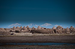
 The ancient Chipaya village The ancient Chipaya village | |
| Coordinates: 19°03′S 68°05′W / 19.050°S 68.083°W / -19.050; -68.083 | |
| Country | |
| Department | Oruro |
| Province | Sabaya Province |
| Municipality | Chipaya Municipality |
| Population | |
| • Total | 363 |
| Time zone | UTC-4 (BOT) |
Chipaya is a village in Bolivia located in the Sabaya Province (formerly Atahuallpa Province) of the Oruro Department. It is the seat of the Chipaya Municipality. In 2001 it had a population of 363. The village is situated in a remote area northeast of Lake Coipasa where the people have maintained special elements of their culture.
Chipaya was declared a National Monument by Supreme Decrete No. 8171 on December 7, 1967.
Climate

See also
References
- National Institute of Statistics (INE) 2001 Archived 2014-02-21 at the Wayback Machine
- ine.gob.bo/publicaciones/ Archived 2014-02-21 at the Wayback Machine Chipaya Municipality: Population data and map
- bolivia.com Viceministerio de Desarollo de las Culturas, Bolivia, Patrimonio Cultural, Monumentos Nacionales Declarados por el Estado Boliviano: "Pueblo y Parroquia de Chipaya"
This Oruro Department location article is a stub. You can help Misplaced Pages by expanding it. |
