| Chiascio | |
|---|---|
 Chiascio Chiascio | |
 | |
| Location | |
| Country | Umbria, Italy |
| Physical characteristics | |
| Source | |
| • location | Monte Cucco |
| • elevation | 850 m (2,790 ft) |
| Mouth | Tiber |
| • location | Torgiano |
| • coordinates | 43°01′06″N 12°25′50″E / 43.01833°N 12.43056°E / 43.01833; 12.43056 |
| Length | 95 km (59 mi) |
| Basin size | 1,962 km (758 sq mi) |
| Discharge | |
| • average | 20 m/s (710 cu ft/s) |
| Basin features | |
| Progression | Tiber→ Tyrrhenian Sea |
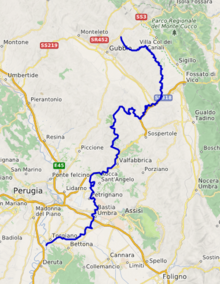
The Chiascio is a river of Umbria, central Italy. It is a left tributary of the Tiber. It is 95 km long, and its drainage basin covers 1962 km. Its largest tributary is the Topino, which covers 60% of its drainage basin.
References
- Agenzia regionale di protezione ambientale dell'Umbria, Caratterizzazione dei bacini idrografici e dei corpi idrici superficiali, Sottobacino Chiascio , p. 7 of 22.
External links
This Umbria location article is a stub. You can help Misplaced Pages by expanding it. |
This article related to a river in Italy is a stub. You can help Misplaced Pages by expanding it. |