| Casco Bay Bridge | |
|---|---|
 | |
| Coordinates | 43°38′41″N 70°15′24″W / 43.644647°N 70.25656°W / 43.644647; -70.25656 |
| Carries | Motor vehicles and pedestrians |
| Crosses | Fore River |
| Locale | Portland, Maine |
| Characteristics | |
| Design | Multi-Girder Bascule |
| Total length | 4,748 feet (1447.2 m) |
| Longest span | 285 feet (86.9 m) at movable span |
| Clearance below | 65 feet (19.8 m) |
| History | |
| Opened | August 1997 |
| Statistics | |
| Daily traffic | 32,000+ vehicles per day |
| Location | |
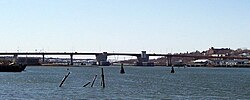
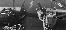
The Casco Bay Bridge is a bascule bridge that spans the Fore River, connecting South Portland and Portland, Maine, United States. The bridge carries four lanes (two in each direction) of State Route 77, a bike lane in each direction, and a pedestrian sidewalk on the east side of the span.
History
In 1987 the state of Maine, in concert with surrounding towns, concluded that the existing Million Dollar Bridge, which was almost 70 years old, was inadequate for current needs. This bridge, also a draw bridge, had only two traffic lanes and offered severely limited clearances for maritime traffic. Given increases in tanker commerce and increased usage of the bridge, a replacement was decided on, and construction started in 1993. The Casco Bay Bridge was completed in 1997.
In October 2015, the Maine Department of Transportation announced that it was seeking bids to privatize the maintenance and operation of the bridge, stating that it would be more cost effective and efficient for taxpayers. If done, it would be the first time the State privatized the operation of a bridge. The Maine State Employees Association questioned the public safety implications of a private entity operating the bridge, as wondered what would happen to the employees who presently operate it.
Design

The new Casco Bay Bridge has four 12 foot (3.7 m) wide lanes, with a pedestrian lane on its eastern side. The bridge is supported by several 7 foot (2.1m meter) thick concrete H-pile cylinders, which the bridge's steel girders sit atop. The new bridge has much higher horizontal and vertical clearances, which allow larger ships access further into the Fore River, with the bascule also having to open less frequently. Extra precautions were taken to ensure that the bridge had sufficient pier protection (during construction to the bridge, the existing Million Dollar Bridge was struck at its piers by the oil tanker Julie N., which spilled roughly 179,600 gallons (679,860 liters) of heating oil into Casco Bay. The bridge's steelwork was painted red in order to make it aesthetically pleasing.
The final cost for the Casco Bay Bridge was $130 million, making it the largest project undertaken by the Maine Department of Transportation at the time.
References
- "State seeks contractor to operate Casco Bay Bridge". Lewiston Sun Journal. Retrieved 2015-10-30.
- ^ "Casco Bay Bridge". Archived from the original on September 27, 2007. Retrieved February 6, 2008.
- "Prize Bridge Award : Moveable Span : Casco Bay Bridge" (PDF). Modernsteel.com. Archived from the original (PDF) on 2012-02-10. Retrieved 2013-12-03.
This article about a bridge in Maine is a stub. You can help Misplaced Pages by expanding it. |
- Bascule bridges in the United States
- Bridges completed in 1997
- Buildings and structures in South Portland, Maine
- Bridges in Portland, Maine
- Road bridges in Maine
- Steel bridges in the United States
- Girder bridges in the United States
- 1997 establishments in Maine
- Northeastern United States bridge (structure) stubs
- Maine building and structure stubs
- Maine transportation stubs