| Brunnenbach | |
|---|---|
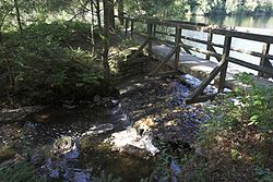
 The Brunnenbach as the tailwater of the Silberteich reservoir The Brunnenbach as the tailwater of the Silberteich reservoir | |
| Location | |
| Country | Germany |
| State | Lower Saxony |
| Location | west and south of Braunlage in Goslar district |
| Physical characteristics | |
| Source | |
| • elevation | over 720 m |
| Mouth | |
| • location | into the Warme Bode |
| • coordinates | 51°41′52″N 10°40′22″E / 51.697861°N 10.672639°E / 51.697861; 10.672639 |
| • elevation | under 500 m |
| Length | 11.9 km (7.4 mi) |
| Basin features | |
| Progression | Warme Bode→ Bode→ Saale→ Elbe→ North Sea |
| Waterbodies | Reservoirs: Silberteich |
The Brunnenbach is a 12 km (7.5 mi) long, right-hand tributary of the Warme Bode, which flows to the west and south of Braunlage in Goslar district in the north German state of Lower Saxony.
Course
Shortly after its source the Brunnenbach is impounded by the Silberteich reservoir, before it continues in a southeasterly direction past the Mutter-Kind-Heim Waldmühle, a mother-and-child centre, and local campsite. It then passes the forest inn of Forellenteich and the forest youth centre of Brunnenbachsmühle [de], before finally turning east. The Brunnenbach is one of the most important tributaries of the Warme Bode.
Tributaries
- Fußstiegbach (left)
- Großer Kronenbach (right)
- Schächerbach (right)
- Blechhüttenbach (left)
References
See also
This Goslar district location article is a stub. You can help Misplaced Pages by expanding it. |
This article related to a river in Lower Saxony is a stub. You can help Misplaced Pages by expanding it. |