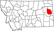
Unincorporated hamlet in Montana, United States
| Bloomfield, Montana | |
|---|---|
| Unincorporated hamlet | |
  | |
| Coordinates: 47°24′46″N 104°55′02″W / 47.41278°N 104.91722°W / 47.41278; -104.91722 | |
| Country | United States |
| State | Montana |
| County | Dawson |
| Area | |
| • Total | 0.06 sq mi (0.15 km) |
| • Land | 0.06 sq mi (0.15 km) |
| • Water | 0.00 sq mi (0.00 km) |
| Elevation | 2,615 ft (797 m) |
| Population | |
| • Total | 6 |
| • Density | 101.69/sq mi (39.27/km) |
| Time zone | UTC-7 (Mountain (MST)) |
| • Summer (DST) | UTC-6 (MDT) |
| ZIP code | 59315 |
| Area code | 406 |
| GNIS feature ID | 780133 |
Bloomfield (formerly, Adams) is a small unincorporated hamlet in Dawson County, Montana, United States. It is located 23 miles (37 km) northeast of the Yellowstone River and the city of Glendive, which is the county seat for Dawson County. Bloomfield is inside area code 406 and has a post office with ZIP code 59315. The population of the community was 150 at the 2010 census.
The town takes its name from Bloomfield, Nebraska, hometown of settlers J. Berton and Dave Crockett. They were soon followed by other Bloomfield families. Previously the town was part of an Amish community.
Demographics
| Census | Pop. | Note | %± |
|---|---|---|---|
| 2020 | 6 | — | |
| U.S. Decennial Census | |||
Climate
According to the Köppen Climate Classification system, Bloomfield has a semi-arid climate, abbreviated "BSk" on climate maps.
References
- "ArcGIS REST Services Directory". United States Census Bureau. Retrieved September 5, 2022.
- ^ "Bloomfield". Geographic Names Information System. United States Geological Survey, United States Department of the Interior.
- "Visit Montana - Bloomfield". Archived from the original on December 31, 2013. Retrieved January 6, 2014.
- "Bloomfield, MT Zip Codes". Zip-Codes.com. Retrieved January 6, 2014.
- "U.S. Census website". United States Census Bureau. Retrieved January 6, 2014.
- ^ "Montana Place Names Companion". Montana Historical Society. Retrieved July 25, 2017.
- "Census of Population and Housing". Census.gov. Retrieved June 4, 2016.
- Climate Summary for Bloomfield, Montana
| Municipalities and communities of Dawson County, Montana, United States | ||
|---|---|---|
| County seat: Glendive | ||
| City |  | |
| Town | ||
| CDPs | ||
This Dawson County, Montana state location article is a stub. You can help Misplaced Pages by expanding it. |