Unincorporated community in Oregon, United States
| Blodgett, Oregon | |
|---|---|
| Unincorporated community | |
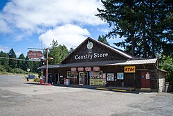
 The Blodgett Country Store The Blodgett Country Store | |
  | |
| Coordinates: 44°35′49″N 123°31′10″W / 44.59694°N 123.51944°W / 44.59694; -123.51944 | |
| Country | United States |
| State | Oregon |
| County | Benton |
| Named for | William Blodgett, a pioneer settler |
| Area | |
| • Total | 0.56 sq mi (1.44 km) |
| • Land | 0.56 sq mi (1.44 km) |
| • Water | 0.00 sq mi (0.00 km) |
| Elevation | 640 ft (200 m) |
| Population | |
| • Total | 42 |
| • Density | 75.68/sq mi (29.20/km) |
| Time zone | UTC-8 (PST) |
| • Summer (DST) | UTC-7 (PDT) |
| ZIP codes | 97326 |
| Area code | 541 |
| FIPS code | 41-06950 |
| GNIS feature ID | 1138266 |
Blodgett is a census-designated place (CDP) and unincorporated community in Benton County, Oregon, United States, where Oregon Route 180 meets U.S. Route 20 in the Central Oregon Coast Range 15 miles (24 km) west of Corvallis. It is near the confluence of the Tumtum and Marys rivers. As of the 2020 census, the community had a population of 42.
Blodgett was named for pioneer settler William Blodgett. The post office was established in April 1888 with the name "Emrick", for a local family, and was changed to Blodgett shortly thereafter. Its ZIP code is 97326.
Blodgett is part of the Philomath School District. The 38-student Blodgett Elementary School serves kindergarten through fourth grade; older students attend schools in nearby Philomath.
Climate
This region experiences warm (but not hot) and dry summers, with no average monthly temperatures above 71.6 °F (22.0 °C). According to the Köppen Climate Classification system, Blodgett has a warm-summer Mediterranean climate, abbreviated "Csb" on climate maps.
Demographics
| Census | Pop. | Note | %± |
|---|---|---|---|
| 2020 | 42 | — | |
| U.S. Decennial Census | |||
References
- ^ McArthur, Lewis A.; Lewis L. McArthur (2003) . Oregon Geographic Names (Seventh ed.). Portland, Oregon: Oregon Historical Society Press. p. 90. ISBN 0-87595-277-1.
- "ArcGIS REST Services Directory". United States Census Bureau. Retrieved October 12, 2022.
- ^ U.S. Geological Survey Geographic Names Information System: Blodgett, Oregon
- ^ "Census Population API". United States Census Bureau. Retrieved October 12, 2022.
- "Explore Census Data". data.census.gov. Retrieved August 18, 2024.
- "Look Up a ZIP Code". U.S. Postal Service. Retrieved April 6, 2015.
- "About Blodgett Elementary". Philomath School District. Archived from the original on February 27, 2015. Retrieved April 6, 2015.
- Climate Summary for Blodgett, Oregon
- "Census of Population and Housing". Census.gov. Retrieved June 4, 2016.
| Municipalities and communities of Benton County, Oregon, United States | ||
|---|---|---|
| County seat: Corvallis | ||
| Cities |  | |
| CDPs | ||
| Other unincorporated communities | ||
| Footnotes | ‡This populated place also has portions in an adjacent county or counties | |
This Benton County, Oregon state location article is a stub. You can help Misplaced Pages by expanding it. |