| Bighorn Mountain | |
|---|---|
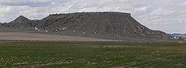
 Bighorn Mountain, seen from the southeast Bighorn Mountain, seen from the southeast | |
| Highest point | |
| Elevation | 4,730 ft (1,440 m) |
| Coordinates | 41°32′27″N 103°31′55″W / 41.5408078°N 103.5318845°W / 41.5408078; -103.5318845 |
| Geography | |
 | |
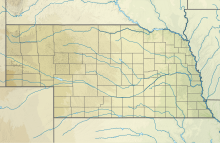
| Location | Banner County, Nebraska, U.S. |
| Topo map | Indian Springs |
Bighorn Mountain, or He Sha, is located in Banner County, about 10.8 miles (17.4 km) east of the county seat of Harrisburg, in the Wildcat Hills of Nebraska, United States.
The peak was named for the bighorn sheep that once roamed its flanks, and were reintroduced in the 1970s.
Many residents of the county have carved their names at the top of the peak; the practice dates back at least to 1887.
See also
References
- "Bighorn Mountain". ListsOfJohn.com. Retrieved January 13, 2013.
- "Bighorn Mountain". Geographic Names Information System. United States Geological Survey, United States Department of the Interior. Retrieved October 19, 2011.
- Beach, F.C. and Rines, G.E. (1912) The Americana: A Universal Reference Library. New York: Scientific American.
- Fitzpatrick, L.L., Link, J.T., and Fairclough, G.T. (1960) Nebraska Place-Names. University of Nebraska Press. p 219.
- Grier, B. (2007) "Bighorn Wildlife Management Area," Nebraskaland magazine. October 1, 2007. p 20-29.
- Snyder, M. and Snyder. (1998) "A history of Banner County", Old Time Nebraska. Retrieved 6/7/08.