| Native name: Pulau Besar (Rumi) ڤولاو بسر (Jawi) | |
|---|---|
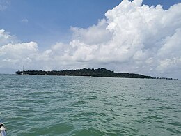
 Besar Island seen from Umbai Besar Island seen from Umbai | |
| Geography | |
| Location | Strait of Malacca |
| Coordinates | 2°6′30.8″N 102°19′37.83″E / 2.108556°N 102.3271750°E / 2.108556; 102.3271750 |
| Archipelago | Water Islands |
| Area | 1.35 km (0.52 sq mi) |
| Administration | |
| State | |
| District | Melaka Tengah |
| Mukim | Pernu |
| Additional information | |
| Time zone | |
| Postal code | 75460 |
Besar Island ("Big Island", Malay: Pulau Besar, in Jawi Script: ڤولاو بسر) is an island approximately 13 km off the coast of mainland Malacca in Malaysia. It is served by 15-minute private motorboat rides from the towns of Pernu and Umbai and 30-minute scheduled ferry rides from Anjung Batu Jetty in Umbai.
Tourist attractions
There are a few attractions which spread across the island, including the tombs of Baghdad-born Islamic preacher Sultan Al Ariffin Syeikh Ismail and his relatives, who were part of an entourage responsible for the spread of Islam throughout the Malay Archipelago after arriving at the island in 1495.
There are also tombs of local figures, unmarked graves and numerous mystical and legendary old wells and rock formations. According to local legends, one of the wells is believed to contain salt water at high tide and fresh water during low tide. The island is believed to be the home of elves known as Orang bunian and there is a cave known as Yunos Cave (Malay: Gua Yunos), where warriors were said to practice mysticism and learn silat (a type of Malay martial arts) in the past.
The Besar Island Museum (Malay: Muzium Pulau Besar), operated by the state's Museum Corporation displays various information related to the island's sights and legend.
Facilities
There is one religious school located on the northeastern tip of the island, adjacent to the jetty. One resort – Putera Island Resort is currently operating on the east side of the island. However, another resort – Marina Resort on the west side is currently abandoned.
A 4.2-kilometre long sea-crossing overhead power line supported by 12 monopoles, which began operations on 28 February 2015, was built to supply electricity to the island from nearby Siring Beach in Serkam, Jasin District.
Gallery
-
 White sandy beach in Besar Island near the jetty, overlooking Lalang Island.
-
 Shuttle boat to Besar Island
-
 Freshwater well in Besar Island
See also
References
- "Pulau Besar Melaka". malaysiasite.nl. Retrieved 4 June 2023.
- "Anjung Batu Jetty". mpjasin.gov.my.
- "Jeti Anjung Batu". mpjasin.gov.my.
- Rahimah Abdullah (6 September 2020). "'Pulau Khurafat' tidak lagi seperti dulu: Mahu cari 'sesuatu'? Carilah keseronokan berekreasi saja!". Astro Awani. Retrieved 4 June 2023.
- "Tomb of Sultan Al Ariffin Syeikh Ismail Islamic Tomb in Pulau Besar".
- "Pulau Besar, Melaka".
- "Muzium Pulau Besar".
- "Putera Island Resort Website".
- "Pulau Besar Receives Electricity Supply" (PDF). tnb.com.my. Malay Mail. 13 June 2016.
| Geography of Malacca | |
|---|---|
| Islands | |
| Seas | |
| Exclaves | |
| Rivers | |
| Capital: Malacca City, Administrative capital: Ayer Keroh | |||||||||||||||
| Topics | |||||||||||||||
| Society | |||||||||||||||
| Administrative divisions |
| ||||||||||||||
This article about an island of Malaysia is a stub. You can help Misplaced Pages by expanding it. |