| Basel–Pratteln | |||||||||||||||||||||||||||||||||||||||||||||||||||||||||||||||||||||||||||||||||||||||||||||||||||||||||||||||||||||||||||||||||||||||||||||||||||||||||||||||||
|---|---|---|---|---|---|---|---|---|---|---|---|---|---|---|---|---|---|---|---|---|---|---|---|---|---|---|---|---|---|---|---|---|---|---|---|---|---|---|---|---|---|---|---|---|---|---|---|---|---|---|---|---|---|---|---|---|---|---|---|---|---|---|---|---|---|---|---|---|---|---|---|---|---|---|---|---|---|---|---|---|---|---|---|---|---|---|---|---|---|---|---|---|---|---|---|---|---|---|---|---|---|---|---|---|---|---|---|---|---|---|---|---|---|---|---|---|---|---|---|---|---|---|---|---|---|---|---|---|---|---|---|---|---|---|---|---|---|---|---|---|---|---|---|---|---|---|---|---|---|---|---|---|---|---|---|---|---|---|---|---|---|
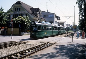
 A BVB tram crosses the Schlossstrasse in 1987, near the terminus in Pratteln A BVB tram crosses the Schlossstrasse in 1987, near the terminus in Pratteln | |||||||||||||||||||||||||||||||||||||||||||||||||||||||||||||||||||||||||||||||||||||||||||||||||||||||||||||||||||||||||||||||||||||||||||||||||||||||||||||||||
| Overview | |||||||||||||||||||||||||||||||||||||||||||||||||||||||||||||||||||||||||||||||||||||||||||||||||||||||||||||||||||||||||||||||||||||||||||||||||||||||||||||||||
| Owner | Baselland Transport | ||||||||||||||||||||||||||||||||||||||||||||||||||||||||||||||||||||||||||||||||||||||||||||||||||||||||||||||||||||||||||||||||||||||||||||||||||||||||||||||||
| Service | |||||||||||||||||||||||||||||||||||||||||||||||||||||||||||||||||||||||||||||||||||||||||||||||||||||||||||||||||||||||||||||||||||||||||||||||||||||||||||||||||
| Services | 14 | ||||||||||||||||||||||||||||||||||||||||||||||||||||||||||||||||||||||||||||||||||||||||||||||||||||||||||||||||||||||||||||||||||||||||||||||||||||||||||||||||
| Operator(s) | Basler Verkehrs-Betriebe | ||||||||||||||||||||||||||||||||||||||||||||||||||||||||||||||||||||||||||||||||||||||||||||||||||||||||||||||||||||||||||||||||||||||||||||||||||||||||||||||||
| History | |||||||||||||||||||||||||||||||||||||||||||||||||||||||||||||||||||||||||||||||||||||||||||||||||||||||||||||||||||||||||||||||||||||||||||||||||||||||||||||||||
| Opened | 22 January 1921 (1921-01-22) | ||||||||||||||||||||||||||||||||||||||||||||||||||||||||||||||||||||||||||||||||||||||||||||||||||||||||||||||||||||||||||||||||||||||||||||||||||||||||||||||||
| Technical | |||||||||||||||||||||||||||||||||||||||||||||||||||||||||||||||||||||||||||||||||||||||||||||||||||||||||||||||||||||||||||||||||||||||||||||||||||||||||||||||||
| Line length | 6.2 km (3.9 mi) | ||||||||||||||||||||||||||||||||||||||||||||||||||||||||||||||||||||||||||||||||||||||||||||||||||||||||||||||||||||||||||||||||||||||||||||||||||||||||||||||||
| Track gauge | 1,000 mm (3 ft 3+3⁄8 in) metre gauge | ||||||||||||||||||||||||||||||||||||||||||||||||||||||||||||||||||||||||||||||||||||||||||||||||||||||||||||||||||||||||||||||||||||||||||||||||||||||||||||||||
| Electrification | 600 V DC | ||||||||||||||||||||||||||||||||||||||||||||||||||||||||||||||||||||||||||||||||||||||||||||||||||||||||||||||||||||||||||||||||||||||||||||||||||||||||||||||||
| |||||||||||||||||||||||||||||||||||||||||||||||||||||||||||||||||||||||||||||||||||||||||||||||||||||||||||||||||||||||||||||||||||||||||||||||||||||||||||||||||
The Basel–Pratteln railway line is a 1,000 mm (3 ft 3+3⁄8 in) railway line in Switzerland. It runs 6.2 kilometres (3.9 mi) from Pratteln to the border of Basel-Stadt, across the river Birs from St. Jakob-Park, where it connects with the Basel tram network. The line was built by the Basellandschaftliche Ueberlandbahn [de] in 1921 and is now owned by Baselland Transport. Basler Verkehrs-Betriebe operates line 14 of the Basel tram network over the line.
History
The Basellandschaftliche Ueberlandbahn [de] opened a line from the existing tram network at Schänzli, on the river Birs, to Muttenz, on 22 January 1921. Trains continued over the Basel tram network and terminated at Aeschenplatz [de]. The line was further extended to its present terminus in Pratteln, near the Swiss Federal Railways station there, on 20 October 1922. The line was electrified from opening at 550 V DC, later increased to 600 V DC. A planned extension from Pratteln to Liestal was never built. In 1974, the Basellandschaftliche Ueberlandbahn merged with three other companies to form Baselland Transport. A 3.2-kilometre (2.0 mi) proposed extension northeast to the Salina Raurica [de] area was rejected by voters in 2021.
Route
The line begins from a turning loop 160 metres (520 ft) south of the Swiss Federal Railways station at Pratteln. It runs east-west, roughly parallel to the standard gauge Hauenstein Railway, and runs through the municipalities of Pratteln and Muttenz. The line is double-tracked, running at-grade on dedicated right-of-way. It crosses the river Birs near St. Jakob-Park, where it connects with the Basel tram network.
Operation
Basler Verkehrs-Betriebe operates line 14 of the Basel tram network over the line. Trams operate at frequent intervals from Pratteln via Aeschenplatz to Dreirosenbrücke [de], on the north side of Basel.
Notes
- ^ Eisenbahnatlas Schweiz. Cologne: Schweers + Wall. 2012. p. 62. ISBN 978-3-89494-130-7.
- Wägli & Jacobi 2010, p. 29.
- Wägli & Jacobi 2010, p. 67.
- Bützer & Jeker 1980, p. 89.
- Wägli & Jacobi 2010, p. 107.
- "Tramlinie 14". Salina Raurica (in Swiss High German). Retrieved 21 November 2022.
- "Pratteln Schlossstrasse - Muttenz - Basel Dreirosenbrücke" (PDF) (in German). Basler Verkehrs-Betriebe. 7 November 2022. Retrieved 20 November 2022.
References
- Bützer, Hans-Peter; Jeker, Mark (1980). Grosser Eisenbahn-Atlas Schweiz (in German). Bern: Kümmerly & Frey. ISBN 978-3-259-03233-6. OCLC 1222543836.
- Wägli, Hans G.; Jacobi, Sébastien (2010). Schienennetz Schweiz - Bahnprofil Schweiz CH+ [Swiss rail network] (in German) (3rd ed.). Zürich: AS Verlag. ISBN 978-3-909111-74-9.