| This article relies largely or entirely on a single source. Relevant discussion may be found on the talk page. Please help improve this article by introducing citations to additional sources. Find sources: "Banaripara Upazila" – news · newspapers · books · scholar · JSTOR (March 2020) |
| Banaripara বানারীপাড়া | |
|---|---|
| Upazila | |
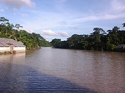
 View of river in Karpara View of river in Karpara | |
 | |
| Coordinates: 22°46.9′N 90°10′E / 22.7817°N 90.167°E / 22.7817; 90.167 | |
| Country | |
| Division | Barisal |
| District | Barisal |
| Headquarters | Banaripara |
| Area | |
| • Total | 134.32 km (51.86 sq mi) |
| Population | |
| • Total | 169,876 |
| • Density | 1,300/km (3,300/sq mi) |
| Time zone | UTC+6 (BST) |
| Postal code | 8530 |
| Area code | 04332 04320 |
| Website | banaripara |
Banaripara (Bengali: বানারীপাড়া) is an upazila of Barishal District in the Division of Barishal in southern-central Bangladesh.
History
During the Liberation War in 1971, the Pakistan Army killed 212 in Gava Village, where all Ghosh Dastidar and Ghosh Ray used to live and they mostly left their ancestral land for India. The villagers were rounded by local collaborators of the Pakistan Army, Akkas Ali Khan and Sarat Samaddar, in front of a canal and told their photos would be taken. Instead the Pakistan Army shot and killed the 200 people gathered there. The Beni Bahini fought against the Pakistan Army in the Upazila.
Geography
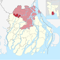
Banaripara is located at 22°46′55″N 90°10′00″E / 22.7819°N 90.1667°E / 22.7819; 90.1667. It has a total area of 134.32 km. It is surrounded by Wazirpur to the north and the east, Nesarabad to the south, Jhalokati to the east, Nazirpur to the west. The upazila is criss-crossed by many rivers. Banaripara pourashava stands on the Shandhya. River erosion is a matter of concern for this area.
Demographics
| Religions in Banaripara Upazila (2022) | ||||
|---|---|---|---|---|
| Religion | Percent | |||
| Islam | 85.87% | |||
| Hinduism | 13.88% | |||
| Other or not stated | 0.25% | |||
According to the 2011 Census of Bangladesh, Banaripara Upazila had 34,186 households and a population of 148,188. 31,694 (21.39%) were under 10 years of age. Banaripara had a literacy rate (age 7 and over) of 67.25%, compared to the national average of 51.8%, and a sex ratio of 1028 females per 1000 males. 16,882 (11.39%) lived in urban areas.
According to the 1991 Bangladeshi census, Banaripara had a population of 143,825. Males constituted 50.67% of the population, and females 49.33%. The population aged 18 or over was 70,724.
Administration
UNO: Antara Haldar.
Banaripara was established as a thana in 1913 and in 1983 it was upgraded as an upazila.
Banaripara Upazila is divided into Banaripara Municipality and eight union parishads: Baisari, Banaripara, Bisarkandi, Chakhar, Iluhar, Saliabakpur, Saidkati, and Udaykati. The union parishads are subdivided into 76 mauzas and 76 villages.
Archaeological heritage and relics
There are two Swathidaha Maths, a copper Manasa Bigraga weighing 3.5 maunds and a six-foot-high Bigraha at Narattampur (200 years old) which used to be family lineage of the Ghosh Ray family of Narratampur.
Education
See also: Education in BangladeshThere are three colleges in the upazila. Government Fazlul Huq College, founded in 1940, is the only public one.
There are 27 high schools, 80 government primary schools, 41 non-government primary schools, 59 madrassas, 1 school for the deaf and dumb and 1 commercial school in this upazila.
According to Banglapedia, Baisari High School, founded in 1880, Govt. Banaripara Model Union Institution (Pilot), (1889), and Nalasree Government Primary School (1910) are notable schools.
Notable people
- Syed Azizul Huq, former Education Minister of Bangladesh
Maps
Official Map of the Banaripara Upazila
References
- National Report (PDF). Population and Housing Census 2022. Vol. 1. Dhaka: Bangladesh Bureau of Statistics. November 2023. p. 395. ISBN 978-9844752016.
- "Bangladesh Postal Code". Dhaka: Bangladesh Postal Department under the Department of Posts and Telecommunications of the Ministry of Posts, Telecommunications and Information Technology of the People's Republic of Bangladesh. 21 October 2024.
- "Bangladesh Area Code". China: Chahaoba.com. 18 October 2024.
- "Bangladesh Area Code". Stockholm, Sweden: Rebtel.com. 18 October 2024.
- ^ Rahman, Kazi Mizanur (2012). "Banaripara Upazila". In Islam, Sirajul; Jamal, Ahmed A. (eds.). Banglapedia: National Encyclopedia of Bangladesh (Second ed.). Asiatic Society of Bangladesh.
- ^ Ghosh, Sushanta (2021-03-26). "The battle of Beni Commander". The Daily Star. Retrieved 2023-07-29.
- Population and Housing Census 2022 - District Report: Barishal (PDF). District Series. Dhaka: Bangladesh Bureau of Statistics. June 2024. ISBN 978-984-475-251-1.
- "Bangladesh Population & Housing Census 2011 for Barisal District (Zila Series)" (PDF). Retrieved 22 September 2020.
- উপজেলা নির্বাহী অফিসার. 2024-08-26. Archived from the original on 2024-08-26.
- "District Statistics 2011: Barisal" (PDF). Bangladesh Bureau of Statistics. Archived from the original (PDF) on 13 November 2014. Retrieved 14 July 2014.
- Ahmed, Siraj Uddin (2010). "চাখারের মজুমদার ও সৈয়দ পরিবার" [The Majumdars and Syed family of Chakhar]. বরিশাল বিভাগের ইতিহাস [History of the Barisal Division] (in Bengali). Vol. 1. Dhaka: Bhaskar Prakashani.
| Cities, towns and locations in Barisal District | |||||||||||||||||||||
|---|---|---|---|---|---|---|---|---|---|---|---|---|---|---|---|---|---|---|---|---|---|
| Cities, municipal and towns |
| ||||||||||||||||||||
| Neighbourhoods and localities |
| ||||||||||||||||||||
| See also | |||||||||||||||||||||
| Capital: Barisal | ||
| Barguna District |  | |
| Barisal District | ||
| Bhola District | ||
| Jhalokati District | ||
| Patuakhali District | ||
| Pirojpur District | ||