| Artjärvi Artsjö | |
|---|---|
| Former municipality | |
| Artjärven kunta Artsjö kommun | |
 Coat of arms Coat of arms | |
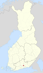
 Location of Artjärvi in Finland Location of Artjärvi in Finland | |
| Coordinates: 60°44.8′N 026°03.2′E / 60.7467°N 26.0533°E / 60.7467; 26.0533 | |
| Country | Finland |
| Region | Päijänne Tavastia |
| Sub-region | Lahti sub-region |
| Charter | 1865 |
| Consolidated | 2011 |
| Government | |
| • Municipal manager | Kimmo Kuparinen |
| Area | |
| • Total | 197.33 km (76.19 sq mi) |
| • Land | 177.01 km (68.34 sq mi) |
| • Water | 20.32 km (7.85 sq mi) |
| Population | |
| • Total | 1,412 |
| • Density | 7.2/km (19/sq mi) |
| Population by native language | |
| • Finnish | 97.8% (official) |
| • Swedish | 0.8% |
| • Others | 1.4% |
| Population by age | |
| • 0 to 14 | 14.1% |
| • 15 to 64 | 59.7% |
| • 65 or older | 26.2% |
| Time zone | UTC+2 (EET) |
| • Summer (DST) | UTC+3 (EEST) |
| Climate | Dfb |
| Website | www.artjarvi.fi |
Artjärvi (Finnish: [ˈɑrtˌjærʋi]; Swedish: Artsjö) is a former municipality of Finland. It was consolidated with the town of Orimattila on January 1, 2011.
The municipality was located in the Päijänne Tavastia region. It had a population of 1,412 (31 October 2010) and covered a land area of 177.01 square kilometres (68.34 sq mi). The population density was 7.98 inhabitants per square kilometre (20.7/sq mi).
The municipality was unilingually Finnish.
History
The name Artjärvi originally only referred to a nearby lake. In the 15th century, Artjärvi was the center of a taxation division, when it was also known as Sääksjärvi. Artjärvi, at the time a part of the Lapinjärvi parish, became the center of a chapel community in 1636. It became independent in 1865.
Artjärvi was consolidated with Orimattila in 2011.
References
- ^ "Area by municipality as of 1 January 2010" (PDF) (in Finnish and Swedish). Land Survey of Finland. Retrieved 23 November 2010.
- ^ "Population by municipality as of 31 October 2010". Population Information System (in Finnish and Swedish). Population Register Center of Finland. Archived from the original on 2010-12-27. Retrieved 16 December 2010.
- "Population according to language and the number of foreigners and land area km2 by area as of 31 December 2008". Statistics Finland's PX-Web databases. Statistics Finland. Retrieved 29 March 2009.
- "Population according to age and gender by area as of 31 December 2008". Statistics Finland's PX-Web databases. Statistics Finland. Retrieved 28 April 2009.
- "1.1.2011 yhdistyvien kuntien uudet nimet". Kunnat.net (in Finnish). Helsinki: Suomen Kuntaliitto. 2 July 2010. Archived from the original on 15 April 2007. Retrieved January 1, 2011.
- "Artjärvi ja Orimattila yhteen 2011". Yle (in Finnish). 22 March 2010. Retrieved 7 August 2022.
- "SuomalainenPaikannimikirja_e-kirja_kuvallinen.pdf" (PDF). kaino.kotus.fi (in Finnish). p. 27. Retrieved August 25, 2022.
External links
![]() Media related to Artjärvi at Wikimedia Commons
Media related to Artjärvi at Wikimedia Commons
- Municipality of Artjärvi – Official website (in Finnish)

| Municipalities of Päijät-Häme | ||
|---|---|---|
| Municipalities |  | |
| Former municipalities | ||
This Southern Finland location article is a stub. You can help Misplaced Pages by expanding it. |