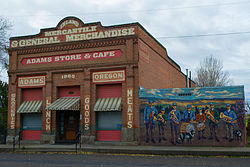
City in Oregon, United States
| Adams, Oregon | |
|---|---|
| City | |
 | |
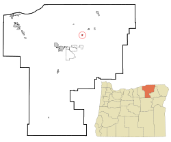
 Location in Oregon Location in Oregon | |
| Coordinates: 45°45′59″N 118°33′51″W / 45.76639°N 118.56417°W / 45.76639; -118.56417 | |
| Country | United States |
| State | Oregon |
| County | Umatilla |
| Incorporated | 1893 |
| Area | |
| • Total | 0.35 sq mi (0.92 km) |
| • Land | 0.35 sq mi (0.92 km) |
| • Water | 0.00 sq mi (0.00 km) |
| Elevation | 1,516 ft (462 m) |
| Population | |
| • Total | 389 |
| • Density | 1,095.77/sq mi (422.82/km) |
| Time zone | UTC-8 (Pacific) |
| • Summer (DST) | UTC-7 (Pacific) |
| ZIP code | 97810 |
| Area codes | 458 and 541 |
| FIPS code | 41-00350 |
| GNIS feature ID | 2409662 |
| Website | www.cityofadamsoregon.com |
Adams is a city in Umatilla County, Oregon, United States, located about 13 miles (21 km) northeast of Pendleton on Oregon Route 11. The population was 350 at the 2010 census. It is part of the Pendleton–Hermiston Micropolitan Statistical Area.
History
Adams was named for a local homesteader, John F. Adams. Adams post office was established in 1883. The city was incorporated by the Oregon Legislative Assembly on February 10, 1893.
Geography
According to the United States Census Bureau, the city has a total area of 0.36 square miles (0.93 km), all of it land.
Climate
According to the Köppen Climate Classification system, Adams has a warm-summer Mediterranean climate, abbreviated "Csa" on climate maps.
Demographics
| Census | Pop. | Note | %± |
|---|---|---|---|
| 1900 | 268 | — | |
| 1910 | 205 | −23.5% | |
| 1920 | 198 | −3.4% | |
| 1930 | 178 | −10.1% | |
| 1940 | 169 | −5.1% | |
| 1950 | 154 | −8.9% | |
| 1960 | 192 | 24.7% | |
| 1970 | 219 | 14.1% | |
| 1980 | 240 | 9.6% | |
| 1990 | 223 | −7.1% | |
| 2000 | 297 | 33.2% | |
| 2010 | 350 | 17.8% | |
| 2020 | 389 | 11.1% | |
| U.S. Decennial Census | |||
2010 census
As of the census of 2010, there were 350 people, 133 households, and 92 families living in the city. The population density was 972.2 inhabitants per square mile (375.4/km). There were 141 housing units at an average density of 391.7 per square mile (151.2/km). The racial makeup of the city was 91.4% White, 0.3% African American, 2.0% Native American, 2.3% from other races, and 4.0% from two or more races. Hispanic or Latino of any race were 6.9% of the population.
There were 133 households, of which 32.3% had children under the age of 18 living with them, 52.6% were married couples living together, 7.5% had a female householder with no husband present, 9.0% had a male householder with no wife present, and 30.8% were non-families. 26.3% of all households were made up of individuals, and 12.8% had someone living alone who was 65 years of age or older. The average household size was 2.63 and the average family size was 3.12.
The median age in the city was 40.6 years. 24.6% of residents were under the age of 18; 6% were between the ages of 18 and 24; 25.5% were from 25 to 44; 27.7% were from 45 to 64; and 16.3% were 65 years of age or older. The gender makeup of the city was 54.0% male and 46.0% female.

2000 census
As of the census of 2000, there were 297 people, 106 households, and 80 families living in the city. The population density was 863.1 inhabitants per square mile (333.2/km). There were 118 housing units at an average density of 342.9 per square mile (132.4/km). The racial makeup of the city was 95.96% White, 2.02% Native American, 0.67% Asian, 0.34% from other races, and 1.01% from two or more races. Hispanic or Latino of any race were 0.34% of the population.
There were 106 households, out of which 31.1% had children under the age of 18 living with them, 65.1% were married couples living together, 7.5% had a female householder with no husband present, and 23.6% were non-families. 22.6% of all households were made up of individuals, and 8.5% had someone living alone who was 65 years of age or older. The average household size was 2.75 and the average family size was 3.16.
In the city, the population was spread out, with 29.0% under the age of 18, 7.7% from 18 to 24, 29.3% from 25 to 44, 22.6% from 45 to 64, and 11.4% who were 65 years of age or older. The median age was 35 years. For every 100 females, there were 102.0 males. For every 100 females age 18 and over, there were 90.1 males.
The median income for a household in the city was $42,500, and the median income for a family was $45,556. Male median income was $33,750, and female median income was $21,538. The per capita income for the city was $14,974. About 4.3% of families and 6.4% of the population were below the poverty line, including 3.1% of those under the age of eighteen and none of those sixty five or over.
References
- "ArcGIS REST Services Directory". United States Census Bureau. Retrieved October 12, 2022.
- ^ U.S. Geological Survey Geographic Names Information System: Adams, Oregon
- ^ "Census Population API". United States Census Bureau. Retrieved October 12, 2022.
- ^ "U.S. Census website". United States Census Bureau. Retrieved December 21, 2012.
- ^ McArthur, Lewis A.; Lewis L. McArthur (2003) . Oregon Geographic Names (Seventh ed.). Portland, Oregon: Oregon Historical Society Press. p. 7. ISBN 0-87595-277-1.
- Leeds, W. H. (1899). "Special Laws". The State of Oregon General and Special Laws and Joint Resolutions and Memorials Enacted and Adopted by the Twentieth Regular Session of the Legislative Assembly. Salem, Oregon: State Printer: 703.
- "US Gazetteer files 2010". United States Census Bureau. Archived from the original on January 25, 2012. Retrieved December 21, 2012.
- "Adams, Oregon". Weatherbase. CantyMedia. Retrieved June 1, 2015.
- "Census of Population and Housing". Census.gov. Retrieved June 4, 2015.
External links
- Entry for Adams in the Oregon Blue Book
- Willingham, William. "Adams". The Oregon Encyclopedia.
| Municipalities and communities of Umatilla County, Oregon, United States | ||
|---|---|---|
| County seat: Pendleton | ||
| Cities |  | |
| CDPs | ||
| Other communities | ||
| Indian reservation | ||
| Ghost towns | ||