This is an old revision of this page, as edited by Pointe Drive (talk | contribs) at 13:38, 29 May 2013 (Category:Historical red-light districts in the United States, copy edit). The present address (URL) is a permanent link to this revision, which may differ significantly from the current revision.
Revision as of 13:38, 29 May 2013 by Pointe Drive (talk | contribs) (Category:Historical red-light districts in the United States, copy edit)(diff) ← Previous revision | Latest revision (diff) | Newer revision → (diff) This article is about the street in Los Angeles. For other uses, see Sunset Boulevard (disambiguation).| Sunset Boulevard | |
|---|---|
 | |
| Major junctions | |
| West end | |
| Major intersections | |
| East end | Figueroa Street in Downtown Los Angeles |


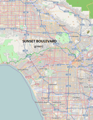
Sunset Boulevard is a street in the western part of Los Angeles County, California that stretches from Figueroa Street in Downtown Los Angeles to the Pacific Coast Highway at the Pacific Ocean in the Pacific Palisades. The street is an icon of Hollywood celebrity culture and the phrase "Sunset Boulevard" is enduring shorthand for the glamor associated with Hollywood.
Geography
Approximately 22 miles (35 km) in length, the famous boulevard roughly mimics the arc of the mountains that form the northern boundary of the Los Angeles Basin, following the path of a 1780s cattle trail from the Pueblo de Los Angeles to the ocean.
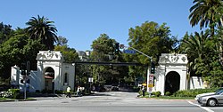
From Downtown Los Angeles, it heads northwest, to Hollywood, through which it travels due west for several miles before it bends southwest towards the ocean. It passes through or near Echo Park, Silver Lake, Los Feliz, Hollywood, West Hollywood, Beverly Hills, Holmby Hills, Bel-Air, Brentwood, and the Pacific Palisades. In Bel-Air Sunset Boulevard runs along the northern boundary of UCLA's Westwood campus.
The boulevard is winding and treacherous in some areas. It is at least four lanes wide along its entire route. Sunset is frequently congested with traffic loads beyond its design capacity.
Sunset Boulevard historically extended farther east than it now does, starting at Alameda Street near Union Station and beside Olvera Street in the historic section of Downtown. The portion of Sunset Boulevard east of Figueroa Street was renamed Cesar Chavez Avenue in 1994 along with Macy Street and Brooklyn Avenue in honor of the late Mexican-American union leader and civil rights activist.
Cultural aspects
The Sunset Strip portion of Sunset Boulevard in West Hollywood has been famous for its active nightlife at least since the 1950s.
In the 1970s the area between Gardner Street and Western Avenue was a center for street prostitution. Shortly after a well publicized June 1995 incident police raids drove out the majority of prostitutes in the area.
Part of Sunset Boulevard in Hollywood is also sometimes called "Guitar Row" due to the large number of guitar stores and music industry-related businesses, including the recording studios Sunset Sound Studios and United Western Recorders.
The portion of Sunset Boulevard that passes through Beverly Hills was once named Beverly Boulevard.
The boulevard is commemorated in Billy Wilder's 1950 film Sunset Boulevard, Andrew Lloyd Webber musical of the same name, and the 1950s television series 77 Sunset Strip. Jan and Dean's 1960s hit song "Dead Man's Curve" refers to a section of the road near Bel Air estates just north of UCLA's Drake Stadium where Jan Berry almost died in an automobile accident in 1966. The Buffalo Springfield song "For What It's Worth" was written about a riot at Pandora's Box, a Sunset Strip club, in 1966.
Metro Local lines 2 and 302 operate on Sunset Boulevard. The Metro Red Line operates a subway station at Vermont Avenue.
Landmarks include (past and present)
- Amoeba Records
- Beverly Hills Hotel
- Blessed Sacrament Church
- Book Soup
- Carney's
- CBS Columbia Square
- Chateau Marmont
- Cinerama Dome
- Comedy Store
- Crossroads of the World
- Directors Guild of America headquarters
- Dudley Do-Right Emporium
- Earl Carroll Theatre
- The Garden of Allah
- Gower Gulch
- Hollywood Athletic Club
- Hollywood High School
- Hollywood Palladium
- Hotel Bel-Air
- House of Blues
- Hyatt West Hollywood
- KCET
- KTLA
- The London Fog
- Los Angeles Film School
- Metromedia Square (the former Fox Television Center and KTTV studios)
- Nickelodeon on Sunset
- Palisades Charter High School
- Psychiatry: An Industry of Death Museum
- Rainbow Bar and Grill
- Rock Walk
- The Roxy Theatre
- Self-Realization Fellowship Lake Shrine
- Spago
- Standard Hotel
- Sunset Junction
- Sunset Gower Studios
- Tiffany Theatre
- Tiki Ti
- UCLA
- Viper Room
- Whisky a Go Go
- Will Rogers State Beach
- Will Rogers State Historic Park
See also
Portal:References
- ^ Bruce Feiler (21 September 2010). America's Prophet: How the Story of Moses Shaped America. HarperCollins. p. 208. ISBN 978-0-06-172627-9. Retrieved 9 August 2012.
- Christopher Hawthorn (July 14, 2012). "For Sunset, a new dawn". Los Angeles Times. Retrieved August 9, 2012.
- Kevin Starr (14 February 2006). Coast of Dreams. Random House. p. 455. ISBN 978-0-679-74072-8. Retrieved 9 August 2012.
- Melissa Hope Ditmore (30 August 2006). Encyclopedia of Prostitution and Sex Work. Greenwood Publishing Group. p. 260. ISBN 978-0-313-32968-5. Retrieved 9 August 2012.
- Frank W. M. Green (5 March 2008). D'Angelico, Master Guitar Builder: What's in a Name?. Hal Leonard Corporation. p. 69. ISBN 978-1-57424-217-1. Retrieved 9 August 2012.
- Matt Warshaw (1 September 2010). The History of Surfing. Chronicle Books. p. 198. ISBN 978-0-8118-5600-3. Retrieved 9 August 2012.
- Cecilia Rasmussen (August 5, 2007). "Closing of club ignited the 'Sunset Strip riots'". Los Angeles Times. Retrieved August 9, 2012.
34°04′51″N 118°25′52″W / 34.0807°N 118.431°W / 34.0807; -118.431 www.SunsetBlvd.us
Categories: