This is an old revision of this page, as edited by Metropolitan (talk | contribs) at 21:15, 2 December 2005. The present address (URL) is a permanent link to this revision, which may differ significantly from the current revision.
Revision as of 21:15, 2 December 2005 by Metropolitan (talk | contribs)(diff) ← Previous revision | Latest revision (diff) | Newer revision → (diff)You must add a |reason= parameter to this Cleanup template – replace it with {{Cleanup|reason=<Fill reason here>}}, or remove the Cleanup template.
Template:Infobox Paris Network
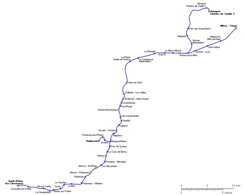
The RER B is one of the five lines in the RER subway system serving Paris, France.
The line runs from Robinson (B2) and Saint-Rémy-lès-Chevreuse (B4) to Aéroport Charles de Gaulle 2-TGV (B3) and Mitry-Claye (B5)
- First inauguration : December 9, 1977
- Length : 80.0 km (49.7 miles)
- Number of stops : 47
- Traffic (2004) : 165,100,000 journeys per annum (figure only for the RATP section of the line)
Line B was the product of the connection in 1977 of the Ligne de Sceaux terminus, Luxembourg, with the Gare du Nord via Châtelet - Les Halles. In 1988 St-Michel - Nôtre-Dame station between Luxembourg and Châtelet - Les Halles was opened to provide connection with Métro Line 10 at Cluny - La Sorbonne, a station which had been closed since the beginning of the second world war and was entirely renovated for the occasion.
Chronology
- 1937 : The CMP (the company which was operating Paris subway then) buys from the PO company the "ligne de Sceaux" which was connecting the Luxembourg Garden to Robinson and Massy-Palaiseau.
- December 9th, 1977 : The ligne de Sceaux is extended to Châtelet-les Halles and becomes the RER B.
- December 10th, 1981 : The line is extended to Charles de Gaulle International Airport.
- January 28th, 1998 : "La Plaine" station is renamed "La Plaine - Stade de France"
Map
