| Revision as of 09:55, 31 October 2013 editYnhockey (talk | contribs)Autopatrolled, Administrators67,005 edits wfy← Previous edit | Revision as of 13:04, 31 October 2013 edit undoAnomieBOT (talk | contribs)Bots6,585,321 editsm Dating maintenance tags: {{Fact}}Next edit → | ||
| (6 intermediate revisions by one other user not shown) | |||
| Line 1: | Line 1: | ||
| {{Infobox Israel village | {{Infobox Israel village | ||
| | name = Avivim | | name = Avivim | ||
| | image = Avivim |
| image = Avivim 6836.jpg | ||
| | caption = | | caption = | ||
| | imgsize = |
| imgsize = 250px | ||
| | founded = | | founded = | ||
| | founded_by = | | founded_by = | ||
| Line 17: | Line 17: | ||
| | website = | | website = | ||
| }} | }} | ||
| ] | |||
| ⚫ | '''Avivim''' ({{lang-he-n|אֲבִיבִים}}), is an ]i ] in the far north of ], in the ]. It is located less than one kilometre (3,000 feet) from the ] with Lebanon, on the lands of the ] village ].{{fact|date=October 2013}} | ||
| ==History== | |||
| ⚫ | In 1920, Saliha was designated part of Lebanon under the auspices of the ]. It was one of 24 villages transferred to British control in 1924 following the 1923 demarcation of the border between the British Mandate for Palestine and the French Mandate for Syria and the Lebanon. | ||
| ⚫ | Under the ], Saliha was to be included in the proposed Arab state, while the boundary between it and the proposed Jewish state was to run north of the built-up area of the village. During the ], Saliha was depopulated and many buildings were destroyed, although the elementary school for boys remained standing. | ||
| ⚫ | '''Avivim''' ({{lang-he-n|אֲבִיבִים}}), is an ]i ] in the far north of ], in the ]. It is located less than one kilometre (3,000 feet) from the ] with Lebanon, on |
||
| ⚫ | |||
| ⚫ | Under the ], Saliha was to be included in the proposed Arab state, while the boundary between it and the proposed Jewish state was to run north of the built-up area of the village. | ||
| During the ], Saliha was the site of a massacre carried out by Israeli forces shortly before the village was completely depopulated. The built structures in the village, with the exception of an elementary school for boys, were also destroyed. | |||
| ⚫ | |||
| ⚫ | Moshav Avivim was founded in 1958, abandoned, and then re-established in 1963 by immigrants from North Africa, mostly ]. | ||
| ==Arab-Israeli conflict== | |||
| The moshav's proximity to the ] ] has made it a target for terrorist attacks, most notably the ]. On May 8, 1970, terrorists from the ] attacked the community ], killing nine children and three adults, and injuring 19 others.<ref></ref> | The moshav's proximity to the ] ] has made it a target for terrorist attacks, most notably the ]. On May 8, 1970, terrorists from the ] attacked the community ], killing nine children and three adults, and injuring 19 others.<ref></ref> | ||
Revision as of 13:04, 31 October 2013
Place in Israel| Avivim | |
|---|---|
 | |
| Country | Israel |
| Council | Merom HaGalil |
| Region | Upper Galilee |
| Affiliation | Moshavim Movement |
| Population | 481 |

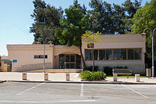
Avivim (Template:Lang-he-n), is an Israeli moshav in the far north of Israel, in the Upper Galilee. It is located less than one kilometre (3,000 feet) from the Blue Line with Lebanon, on the lands of the Shiite village Saliha.
History
In 1920, Saliha was designated part of Lebanon under the auspices of the Franco-British Boundary Agreement. It was one of 24 villages transferred to British control in 1924 following the 1923 demarcation of the border between the British Mandate for Palestine and the French Mandate for Syria and the Lebanon.
Under the 1947 United Nations Partition Plan for Palestine, Saliha was to be included in the proposed Arab state, while the boundary between it and the proposed Jewish state was to run north of the built-up area of the village. During the 1948 Arab–Israeli war, Saliha was depopulated and many buildings were destroyed, although the elementary school for boys remained standing.
Moshav Avivim was founded in 1958, abandoned, and then re-established in 1963 by immigrants from North Africa, mostly Moroccan Jews.
Arab-Israeli conflict
The moshav's proximity to the Lebanese border has made it a target for terrorist attacks, most notably the Avivim school bus massacre. On May 8, 1970, terrorists from the Palestine Liberation Organization attacked the community school bus, killing nine children and three adults, and injuring 19 others.
Avivim also suffered during the 2006 Israel-Lebanon conflict, and was subject to at least one infiltration attempt by Hezbollah. The moshav also came under fire from Hezbollah forces in the nearby village of Maroun al-Ras, across the border in Lebanon.
References
- "Locality File" (XLS). Israel Central Bureau of Statistics. 2012. Retrieved October 30, 2013.
- Israeli-Palestinian Conflict: from Balfour Promise to Bush Declaration, Gabriel G. Tabarani
- "Moshav Avivim still stands determined during tensions", Dan Izenberg, Jerusalem Post, July 20, 2006 (accessed September 7, 2006)
| Merom HaGalil Regional Council | |
|---|---|
| Kibbutzim | |
| Moshavim | |
| Community settlements | |
| Other villages |
|