 Size of this preview: 685 × 599 pixels. Other resolutions: 274 × 240 pixels | 549 × 480 pixels | 878 × 768 pixels | 1,171 × 1,024 pixels | 2,341 × 2,048 pixels | 4,671 × 4,086 pixels.
Original file (4,671 × 4,086 pixels, file size: 13.09 MB, MIME type: image/jpeg)
| This is a file from the Wikimedia Commons. Information from its description page there is shown below. Commons is a freely licensed media file repository. You can help. |
Summary
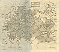
| Description"A Map of the Great Levell, representing it as it lay drowned." (1662).jpg |
English: Caption: "A Map of the Great Levell, representing it as it lay drowned."
Source: Dugdale, William. The History of Imbanking and Drayning of Divers Fenns and Marshes: Both in Forein Parts, and in this Kingdom, and of the Improvement Thereby, Extracted from Records, Manuscripts, and Other Authentick Testimonies. United Kingdom, Warren, 1772. Second Edition. This work was first published in 1662. The scan is from an ex-library book in a private collection. Full text can be found here: https://quod.lib.umich.edu/e/eebo/A36795.0001.001/1:4.30?rgn=div2;view=toc |
| Date | |
| Source | Dugdale, William. The History of Imbanking and Drayning of Divers Fenns and Marshes: Both in Forein Parts, and in this Kingdom, and of the Improvement Thereby, Extracted from Records, Manuscripts, and Other Authentick Testimonies. United Kingdom, Warren, 1772. (Second Edition) |
| Author | Sir William Dugdale |
Licensing
| Public domainPublic domainfalsefalse |
|
This work is in the public domain in its country of origin and other countries and areas where the copyright term is the author's life plus 70 years or fewer. This work is in the public domain in the United States because it was published (or registered with the U.S. Copyright Office) before January 1, 1930. | |
| This file has been identified as being free of known restrictions under copyright law, including all related and neighboring rights. | |
https://creativecommons.org/publicdomain/mark/1.0/PDMCreative Commons Public Domain Mark 1.0falsefalse
Captions
"A Map of the Great Levell, representing it as it lay drowned." from "The history of imbanking and drayning" by William Dugdale (1662). (1662)Items portrayed in this file
depicts
The Fens
Lincolnshire
Cambridgeshire
Suffolk
1662
antique map
drainage
William Dugdale
media type<\/a>"}},"text\/plain":{"en":{"":"media type"}}},"{\"value\":\"image\\\/jpeg\",\"type\":\"string\"}":{"text\/html":{"en":{"P1163":"image\/jpeg"}},"text\/plain":{"en":{"P1163":"image\/jpeg"}}}}">media type
image/jpeg
checksum<\/a>"}},"text\/plain":{"en":{"":"checksum"}}},"{\"value\":\"9f1645e1921461087ba00c8ba4c110e966bb3853\",\"type\":\"string\"}":{"text\/html":{"en":{"P4092":"9f1645e1921461087ba00c8ba4c110e966bb3853"}},"text\/plain":{"en":{"P4092":"9f1645e1921461087ba00c8ba4c110e966bb3853"}}},"{\"value\":{\"entity-type\":\"property\",\"numeric-id\":459,\"id\":\"P459\"},\"type\":\"wikibase-entityid\"}":{"text\/html":{"en":{"":"determination method or standard<\/a>"}},"text\/plain":{"en":{"":"determination method or standard"}}},"{\"value\":{\"entity-type\":\"item\",\"numeric-id\":13414952,\"id\":\"Q13414952\"},\"type\":\"wikibase-entityid\"}":{"text\/html":{"en":{"P459":"SHA-1<\/a>"}},"text\/plain":{"en":{"P459":"SHA-1"}}}}">checksum
9f1645e1921461087ba00c8ba4c110e966bb3853
determination method or standard: SHA-1data size<\/a>"}},"text\/plain":{"en":{"":"data size"}}},"{\"value\":{\"amount\":\"+13724873\",\"unit\":\"http:\\\/\\\/www.wikidata.org\\\/entity\\\/Q8799\"},\"type\":\"quantity\"}":{"text\/html":{"en":{"P3575":"13,724,873 byte<\/span>"}},"text\/plain":{"en":{"P3575":"13,724,873 byte"}}}}">data size
13,724,873 byte
height<\/a>"}},"text\/plain":{"en":{"":"height"}}},"{\"value\":{\"amount\":\"+4086\",\"unit\":\"http:\\\/\\\/www.wikidata.org\\\/entity\\\/Q355198\"},\"type\":\"quantity\"}":{"text\/html":{"en":{"P2048":"4,086 pixel<\/span>"}},"text\/plain":{"en":{"P2048":"4,086 pixel"}}}}">height
4,086 pixel
width<\/a>"}},"text\/plain":{"en":{"":"width"}}},"{\"value\":{\"amount\":\"+4671\",\"unit\":\"http:\\\/\\\/www.wikidata.org\\\/entity\\\/Q355198\"},\"type\":\"quantity\"}":{"text\/html":{"en":{"P2049":"4,671 pixel<\/span>"}},"text\/plain":{"en":{"P2049":"4,671 pixel"}}}}">width
4,671 pixel
inception<\/a>"}},"text\/plain":{"en":{"":"inception"}}},"{\"value\":{\"time\":\"+1662-01-01T00:00:00Z\",\"timezone\":0,\"before\":0,\"after\":0,\"precision\":9,\"calendarmodel\":\"http:\\\/\\\/www.wikidata.org\\\/entity\\\/Q1985727\"},\"type\":\"time\"}":{"text\/html":{"en":{"P571":"1662"}},"text\/plain":{"en":{"P571":"1662"}}}}">inception
1662
File history
Click on a date/time to view the file as it appeared at that time.
| Date/Time | Thumbnail | Dimensions | User | Comment | |
|---|---|---|---|---|---|
| current | 01:39, 14 January 2023 |  | 4,671 × 4,086 (13.09 MB) | Ittybittykittycommittee | Uploaded a work by Sir William Dugdale from Dugdale, William. The History of Imbanking and Drayning of Divers Fenns and Marshes: Both in Forein Parts, and in this Kingdom, and of the Improvement Thereby, Extracted from Records, Manuscripts, and Other Authentick Testimonies. United Kingdom, Warren, 1772. (Second Edition) with UploadWizard |
File usage
The following page uses this file:
Global file usage
The following other wikis use this file:
- Usage on sl.wikipedia.org